Mounted Print > Maps and Charts > Related Images
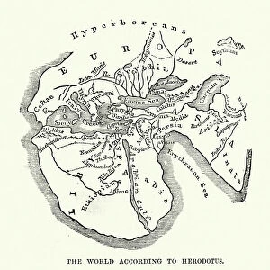
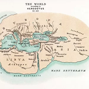
Mounted Print : Earth map according to Herodotus


![]()
Mounted Prints from Fine Art Storehouse
Earth map according to Herodotus
Antique illustration of a earth map according to Herodotus
Unleash your creativity and transform your space into a visual masterpiece!
Nastasic
Media ID 14756838
© This content is subject to copyright
10"x8" Mount with 8"x6" Print
Step back in time with our exquisite Mounted Photo from the Media Storehouse Fine Art Storehouse collection. This captivating piece features an antique illustration of the Earth map according to Herodotus, as beautifully rendered by Nastasic. With intricate details and a vintage aesthetic, this mounted photo is a stunning addition to any home or office. Transport yourself to a bygone era with this unique and thought-provoking piece. Perfect for history enthusiasts, world travelers, or anyone who appreciates the beauty of ancient cartography. Order yours today and let the adventure begin!
Printed on 8"x6" paper and suitable for use in a 10"x8" frame (frame not included). Prints are mounted with card both front and back. Featuring a custom cut aperture to match chosen image. Professional 234gsm Fujifilm Crystal Archive DP II paper.
Photo prints supplied in custom cut card mount ready for framing
Estimated Image Size (if not cropped) is 20.3cm x 13.2cm (8" x 5.2")
Estimated Product Size is 25.4cm x 20.3cm (10" x 8")
These are individually made so all sizes are approximate
Artwork printed orientated as per the preview above, with landscape (horizontal) orientation to match the source image.
FEATURES IN THESE COLLECTIONS
> Fine Art Storehouse
> Map
> Historical Maps
> Maps and Charts
> Related Images
EDITORS COMMENTS
This print showcases an antique illustration of the Earth map according to Herodotus, created by the talented artist Nastasic. Stepping back in time, this artwork takes us on a journey through history and geography, offering a glimpse into how our world was perceived centuries ago. Herodotus, often hailed as the "Father of History" was an ancient Greek historian who meticulously documented his observations and knowledge about various cultures and lands. This particular depiction of the Earth map reflects his understanding during that era, providing us with valuable insights into early cartography. The intricate details captured in this print are truly awe-inspiring. The delicate lines delineating continents and oceans transport us to a time when exploration was at its infancy. Each stroke tells a story of discovery and curiosity about distant lands waiting to be explored. As we gaze upon this remarkable piece of art, we can't help but marvel at how far our understanding of the world has evolved since then. It serves as a reminder that knowledge is ever-evolving and that there is always more to learn about our planet's rich history. Whether you're an avid history enthusiast or simply appreciate fine art, this exquisite print will undoubtedly add depth and intrigue to any space it graces. Let it spark conversations about ancient civilizations, inspire wanderlust for uncharted territories, or serve as a testament to human curiosity throughout the ages - all within the confines of your own home or office.
MADE IN THE UK
Safe Shipping with 30 Day Money Back Guarantee
FREE PERSONALISATION*
We are proud to offer a range of customisation features including Personalised Captions, Color Filters and Picture Zoom Tools
SECURE PAYMENTS
We happily accept a wide range of payment options so you can pay for the things you need in the way that is most convenient for you
* Options may vary by product and licensing agreement. Zoomed Pictures can be adjusted in the Basket.