Mounted Print > Europe > Hungary > Maps
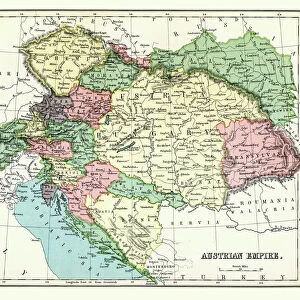
Mounted Print : Antique map of Austria Hungary 19th Century


![]()
Mounted Prints from Fine Art Storehouse
Antique map of Austria Hungary 19th Century
Vintage engraving of a Antique damaged map of Austro-Hungarian Empire in the 19th Century, 1873
Unleash your creativity and transform your space into a visual masterpiece!
duncan1890
Media ID 14756876
© This content is subject to copyright
Austria Hungary Austrian Empire Austro Hungarian Empire
10"x8" Mount with 8"x6" Print
Step back in time with our exquisite Antique Map of Austria-Hungary from the Fine Art Storehouse at Media Storehouse. This vintage engraving, created in the 19th century (1873), showcases an intricately detailed and damaged map of the Austro-Hungarian Empire. The antiqued finish adds character and charm, making it a unique addition to any home or office. Hang this beautiful piece of history on your wall as a conversation starter or a reminder of the past. Experience the rich history and intricate details up close with our high-quality Mounted Photos. Order yours today!
Printed on 8"x6" paper and suitable for use in a 10"x8" frame (frame not included). Prints are mounted with card both front and back. Featuring a custom cut aperture to match chosen image. Professional 234gsm Fujifilm Crystal Archive DP II paper.
Photo prints supplied in custom cut card mount ready for framing
Estimated Image Size (if not cropped) is 19cm x 15.2cm (7.5" x 6")
Estimated Product Size is 25.4cm x 20.3cm (10" x 8")
These are individually made so all sizes are approximate
Artwork printed orientated as per the preview above, with landscape (horizontal) orientation to match the source image.
FEATURES IN THESE COLLECTIONS
> Fine Art Storehouse
> Map
> Historical Maps
> Europe
> Austria
> Related Images
> Europe
> Hungary
> Related Images
> Maps and Charts
> Related Images
EDITORS COMMENTS
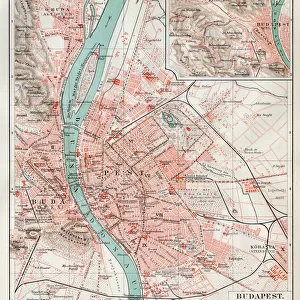
This print showcases an exquisite antique map of Austria Hungary from the 19th century, transporting us back to a time of grandeur and historical significance. The vintage engraving beautifully captures the intricate details of this damaged yet enchanting map, which dates back to 1873. As we gaze upon this piece, we are instantly transported into the heart of the Austro-Hungarian Empire, marveling at its vast territories and diverse landscapes. The delicate lines and faded colors evoke a sense of nostalgia, reminding us of a bygone era filled with imperial splendor. The Austrian Empire's rich history comes alive through this remarkable artwork. It serves as a visual testament to the empire's influence over Central Europe during its peak in the 19th century. From Vienna's elegant architecture to Budapest's majestic bridges spanning across the Danube River, every corner is meticulously depicted on this antique map. Duncan1890 has masterfully captured not just an image but also a story within this photo print. It invites us to explore and appreciate our past while igniting our curiosity about forgotten lands and forgotten times. Whether you are an avid historian or simply captivated by old-world charm, this stunning piece will undoubtedly add character and sophistication to any space it graces. Allow yourself to be transported through time as you immerse yourself in the beauty and intrigue that lies within this Antique Map of Austria Hungary from Fine Art Storehouse.
MADE IN THE UK
Safe Shipping with 30 Day Money Back Guarantee
FREE PERSONALISATION*
We are proud to offer a range of customisation features including Personalised Captions, Color Filters and Picture Zoom Tools
SECURE PAYMENTS
We happily accept a wide range of payment options so you can pay for the things you need in the way that is most convenient for you
* Options may vary by product and licensing agreement. Zoomed Pictures can be adjusted in the Basket.