Mounted Print > Europe > United Kingdom > England > Herefordshire > Ledbury > Charles II
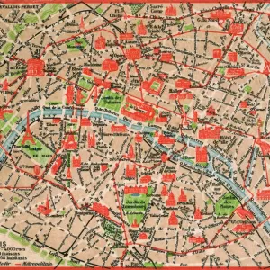
Mounted Print : Detail of the Right Bank, from the map of Paris c. 1540


![]()
Mounted Prints from Fine Art Finder
Detail of the Right Bank, from the map of Paris c. 1540
617394 Detail of the Right Bank, from the map of Paris c. 1540, known as the Plan de la Tapisserie, made as a tapestry c. 1570, 1818 (colour engraving) by Naudet, Caroline (1775-1839); Bibliotheque Historique de la Ville de Paris, Paris, France; (add.info.: Together with the map of Sebastian MAonster and the Plan de la Gouache, this is one of the oldest plans of Paris. The original map was woven as a tapestry c. 1571 for Cardinal Charles de Bourbon (1523-90). In 1571 he was made Lieutenant-General of Paris and Ile de France and his heraldic arms are displayed here. Later the tapestry passed to the Guise family and was kept at the HA'tel de Clisson. The tapestry disappeared during the French Revolution but a copy had been made for the French antiquary, FranAzois de GaigniAres (1642-1715) ecuyer (equerry) to Louis Joseph, duke of Guise (1650-71). This map shows Paris after the beginning of the dismantling in 1533 (on the orders of FranAzois Premier) of the inner Right Bank Enceinte (city wall) of Philippe II Auguste but the sections near the Louvre and in the 3rd and 4th Arrondissements are clearly visible on the map.); French, out of copyright
Media ID 23542096
© Bridgeman Images
16th Armoiries Bourbon Capital City Carte Earliest Ile De La Cite Oldest Right Bank Rive Droite River Seine Street Map Heraldry
10"x8" Mount with 8"x6" Print
Bring the historical charm of old Paris into your home with our exquisite Media Storehouse Mounted Photos. This captivating image showcases a detailed view of the Right Bank of the Seine River as depicted in the 1540 map of Paris by Bridgeman Images from Fine Art Finder. With intricate details of the medieval city's architecture and winding streets, this engraving, made in 1818 by Naudet, transports you back in time. Our high-quality mounted photo is a stunning addition to any room, adding an air of sophistication and history to your decor.
Printed on 8"x6" paper and suitable for use in a 10"x8" frame (frame not included). Prints are mounted with card both front and back. Featuring a custom cut aperture to match chosen image. Professional 234gsm Fujifilm Crystal Archive DP II paper.
Photo prints supplied in custom cut card mount ready for framing
Estimated Image Size (if not cropped) is 15cm x 20.3cm (5.9" x 8")
Estimated Product Size is 20.3cm x 25.4cm (8" x 10")
These are individually made so all sizes are approximate
Artwork printed orientated as per the preview above, with portrait (vertical) orientation to match the source image.
FEATURES IN THESE COLLECTIONS
> Fine Art Finder
> Artists
> Caroline Naudet
> Fine Art Finder
> Artists
> Margaret Jameson
> Fine Art Finder
> Maps (celestial & Terrestrial)
> Europe
> France
> Heritage Sites
> Paris, Banks of the Seine
> Europe
> France
> Paris
> Maps
> Europe
> France
> Paris
> Museums
> The Louvre
> Europe
> France
> Paris
> River Seine
> Europe
> France
> Paris
> Sights
> Louvre
> Europe
> United Kingdom
> England
> Herefordshire
> Ledbury
> Charles II
> Maps and Charts
> Early Maps
> Maps and Charts
> Related Images
EDITORS COMMENTS
This print showcases a remarkable detail of the Right Bank from the map of Paris circa 1540, known as the Plan de la Tapisserie. Created as a tapestry around 1570 by Caroline Naudet, this exquisite piece offers a glimpse into the historical landscape of Paris during that era. Considered one of the oldest plans of Paris alongside Sebastian Maonster's map and the Plan de la Gouache, this particular artwork holds immense significance. Originally woven for Cardinal Charles de Bourbon in 1571, it displays his heraldic arms as he held the position of Lieutenant-General of Paris and Ile de France. Passed down to the Guise family and housed at HA'tel de Clisson, unfortunately, this precious tapestry was lost during the French Revolution. Fortunately for posterity, a copy had been made for FranAzois de GaigniAres, an esteemed French antiquary who served Louis Joseph, Duke of Guise. This detailed map reveals how Paris appeared after significant dismantling began in 1533 under FranAzois Premier's orders to remove parts of Philippe II Auguste's inner Right Bank Enceinte (city wall). Notably visible are sections near iconic landmarks such as Louvre and within the third and fourth Arrondissements. Through this stunning print captured by Bridgeman Images from Fine Art Finder, viewers can immerse themselves in both history and artistry while marveling at this intricate depiction of medieval Parisian urban planning.
MADE IN THE UK
Safe Shipping with 30 Day Money Back Guarantee
FREE PERSONALISATION*
We are proud to offer a range of customisation features including Personalised Captions, Color Filters and Picture Zoom Tools
SECURE PAYMENTS
We happily accept a wide range of payment options so you can pay for the things you need in the way that is most convenient for you
* Options may vary by product and licensing agreement. Zoomed Pictures can be adjusted in the Basket.