Metal Print > Europe > United Kingdom > England > Sussex > Birdham
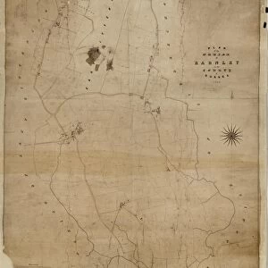
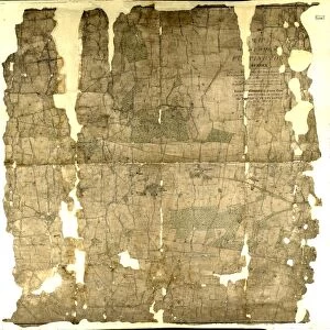
Metal Print : Birdham Tithe Map, c. 1847


![]()
Metal Prints from West Sussex County Council
Birdham Tithe Map, c. 1847
No date, but Tithe Award dated 1847. Surveyor unknown. 26.6 in. to 1 m. Original map size 46in. × 66in.
Tithe Award Map Collection
West Sussex Record Office Ref No: TD/W16
West Sussex County Council Record Office contains a fascinating history of the county of West Sussex, England
Media ID 7915662
© West Sussex County Council - All Rights Reserved
15"x10" (38x25cm) Metal Print
Bring history to life with our stunning Media Storehouse Metal Print of the Birdham Tithe Map from West Sussex County Council. This intricately detailed 1847 Tithe Map, surveyed prior to the Victoria era, offers a captivating glimpse into the past. Originally measuring over 4 feet by 6.5 feet, this meticulously reproduced print preserves the intricacies of the original map, now available in a sleek, modern format. Hang this beautiful piece in your home or office to add a touch of historical charm and conversation-starting appeal.
Your image is printed photographically and bonded to a 3.5mm thick, Dibond board (black polyethylene sandwiched between two sheets of white coated aluminium). The panel is then sealed with a gloss protective covering. Supplied complete with a wall mount which holds the print 10mm from the wall.
Made with durable metal and luxurious printing techniques, metal prints bring images to life and add a modern touch to any space
Estimated Product Size is 38.1cm x 25.4cm (15" x 10")
These are individually made so all sizes are approximate
Artwork printed orientated as per the preview above, with landscape (horizontal) or portrait (vertical) orientation to match the source image.
FEATURES IN THESE COLLECTIONS
> Europe
> United Kingdom
> England
> Sussex
> Birdham
> Europe
> United Kingdom
> England
> Sussex
> Related Images
> Europe
> United Kingdom
> England
> West Sussex
> Related Images
> Maps and Charts
> Related Images
> West Sussex County Council
> West Sussex Record Office
> Tithe Award Maps, 1808-1859
EDITORS COMMENTS
This print showcases the remarkable Birdham Tithe Map, believed to have been created around 1847. Although the exact date remains unknown, it is accompanied by a Tithe Award dated in that same year. The surveyor responsible for this intricate piece of cartography remains a mystery, adding an air of intrigue and fascination to its historical significance. Measuring at an impressive scale of 26.6 inches to 1 meter, the original map size spans an impressive 46 inches by 66 inches. Its meticulous details and precise markings offer a glimpse into the past, providing valuable insights into the landscape and boundaries of Birdham parish during the 1840s. Preserved within West Sussex Record Office's esteemed Tithe Award Map Collection under reference number TD/W16, this artifact serves as a testament to our rich heritage and commitment to preserving historical mapping treasures for future generations. It is important to note that this particular caption emphasizes that it pertains solely to the photograph itself and not any commercial use associated with it. Instead, we are invited on a journey through time as we explore this invaluable relic from West Sussex County Council's archives – one that sheds light on Birdham's history while leaving us pondering about its anonymous creator who skillfully crafted such an extraordinary piece of artistry.
MADE IN THE UK
Safe Shipping with 30 Day Money Back Guarantee
FREE PERSONALISATION*
We are proud to offer a range of customisation features including Personalised Captions, Color Filters and Picture Zoom Tools
SECURE PAYMENTS
We happily accept a wide range of payment options so you can pay for the things you need in the way that is most convenient for you
* Options may vary by product and licensing agreement. Zoomed Pictures can be adjusted in the Basket.