
Metal Print > Sheffield City Archives > Maps and Plans > Sheffield OS maps
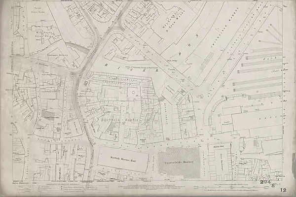
Metal Print : Ordnance Survey Map, Blonk Street area, 1890 (sheet no. Yorkshire No. 294.8.12)
")


![]()
Metal Prints from Sheffield City Archives
Ordnance Survey Map, Blonk Street area, 1890 (sheet no. Yorkshire No. 294.8.12)
This map features:
Top left: River Don, Blonk Goit, Wicker, Wire Works, Blonk Street, Water Lane, Castle Green, Waingate, Slaughter Houses, Mill Sands, Bridge Street, Tramway, Wicker, Gun Lane, Nursery Street, smithy, Mill Walk, [William Buckley and Co], Patent Piston Works on Millsands, [John Kenyon and Co Ltd], Mill Sands Steel Works, [Tennant Brothers Ltd], Exchange Brewery on Bridge Street, Town Mills (corn), Lion Hotel, Crown Inn, Great Gunn Public House, Wicker Brass Works, New White Lion Inn, Corner Pin Public House, Wicker Tilt (steel), Lady's Bridge, Hare and Hounds Public House, Lady's Bridge Hotel Public House, Chandler's Row, Bull and Mouth Hotel Public House, Three Whitesmiths Public House, Bridge Inn, Anvil Inn, [W H Birks and Co.], Lady's Bridge Brewery on Bridge Street, Wheat Sheaf Inn, Hollis Hospital and School.
Top right: River Don, Blonk Goit, Wicker, Wire Works, Blonk Street, River Sheaf, [Samuel Osborn and Co], Clyde Steel and Iron Works, Smithfield Market (including pig pens and cattle pens), Smithfield Hotel Public House, Victoria Hotel Public House, Victoria Station Road, Park Station (Coal and Lime Depot), Manchester, Sheffield and Lincolnshire Railway, Maltravers Street, urinals, Blonk Bridge, [Seebohm and Dieckstahl Limited], Dannemora Steel Works (in margin), Furnival Road, Smithfield Hotel Public House, Alexandra Opera House.
Bottom left: Water Lane, Castle Green, Waingate, Slaughter Houses, Castle Hill, Castle Folds Lane, Sheffield Castle (site of), Haymarket, Castle Street, Snig Hill, Angel Street, Bank Street, Dixon Lane, Town Hall, Norfolk Market Hall, Central Police Station, Royal Hotel, Rose and Crown Inn, New Market Inn, Rotherham House Public House, Norfolk Arms Public House, Rock Tavern, Tontine Hotel Public House, Brunswick Hotel Public House, Old No. 12 (s.v.), Black Rock Public House, Hen and Chickens Hotel Public House, Imperial Hotel, Castle Inn, Angel Inn, Old Queen's Head Public House, Brunswick Hotel Public House, Royal Oak Public House, Wharncliffe Hotel.
Bottom right: Slaughter houses, River Sheaf, Furnival Road, Exchange Place, Castle Folds, Exchange Lane, Wharf Street, Manor Yard, Castlefolds Market, Canal Warehouse, Canal Basin, Victoria Hotel Public House, Alexandra Hotel Public House, Canal Wharf, Smithy, Durham Ox Public House, Canal Bridge, Maunche Hotel, Corn Exchange, Golden Fleece Public House, Park Plate Works, Broad Street.
Additional information from White's General and Commercial Directory of Sheffield, 1896 / Graces Guide.
Surveyed 1889. Heliozincography 70/1901.
Dimensions of original 77 x 102 cm.
Scale 10.56 feet : 1 mile [1:500].
From an original at Sheffield Libraries: q00081 (sheet no. Yorkshire 294.8.12)
Sheffield City Archives and Local Studies Library has an unrivalled collection of images of Sheffield, England
Media ID 33302303
© Sheffield City Council - All Rights Reserved
Old Map Ordnance Survey Os Map Sheffield
15"x10" (38x25cm) Metal Print
Step back in time with our stunning Media Storehouse Metal Print of an Ordnance Survey Map from Sheffield City Archives. This unique piece features the Blonk Street area of Sheffield in 1890 (Sheet No. Yorkshire No. 294.8.12). Discover intricate details of the city's rich history, including the River Don, Blonk Goit, Wicker, Wire Works, Blonk Street, Water Lane, Castle Green, Waingate, Slaughter Houses, Mill Sands, Bridge Street, Tramway, Wicker, and Gun Lane. Our high-quality Metal Print preserves the authenticity of the map's intricate lines and text, making it a captivating addition to any room. Bring history into your home with this beautiful and durable piece of wall art.
Your image is printed photographically and bonded to a 3.5mm thick, Dibond board (black polyethylene sandwiched between two sheets of white coated aluminium). The panel is then sealed with a gloss protective covering. Supplied complete with a wall mount which holds the print 10mm from the wall.
Made with durable metal and luxurious printing techniques, metal prints bring images to life and add a modern touch to any space
Estimated Product Size is 38.1cm x 25.4cm (15" x 10")
These are individually made so all sizes are approximate
Artwork printed orientated as per the preview above, with landscape (horizontal) or portrait (vertical) orientation to match the source image.
EDITORS COMMENTS
Step back in time with this print of the Ordnance Survey Map, Blonk Street area, taken in 1890. This meticulously detailed map offers a glimpse into the bustling streets and landmarks that once defined Yorkshire No. 294.8.12. In the top left corner, we see the meandering River Don alongside Blonk Goit and Wicker, surrounded by industrial sites such as Wire Works and Patent Piston Works on Millsands. The map also highlights notable establishments like Lion Hotel, Crown Inn, and Lady's Bridge Brewery. Moving to the top right section, our eyes are drawn to Smithfield Market with its pig pens and cattle pens adjacent to Clyde Steel and Iron Works. Victoria Station Road leads us towards Park Station while Alexandra Opera House stands proudly nearby. The bottom left quadrant showcases Castle Hill overlooking Water Lane and Waingate where Slaughter Houses were once located. Sheffield Castle's historical site is marked along with prominent buildings like Town Hall and Royal Hotel. Lastly, in the bottom right corner lies Canal Basin flanked by Slaughter houses along River Sheaf. Durham Ox Public House catches our attention amidst Corn Exchange and Broad Street's vibrant atmosphere. This extraordinary snapshot of history was surveyed in 1889 using heliozincography techniques before being transformed into a magnificent print measuring an impressive 77 x 102 cm at a scale of 10.56 feet:1 mile (1:500). Thanks to Sheffield Libraries' collection of original maps like this one (q00081), we can explore Sheffield's past through its streetscapes without commercial use restrictions.
MADE IN THE UK
Safe Shipping with 30 Day Money Back Guarantee
FREE PERSONALISATION*
We are proud to offer a range of customisation features including Personalised Captions, Color Filters and Picture Zoom Tools
SECURE PAYMENTS
We happily accept a wide range of payment options so you can pay for the things you need in the way that is most convenient for you
* Options may vary by product and licensing agreement. Zoomed Pictures can be adjusted in the Basket.