
Metal Print > Maps and Charts > Related Images
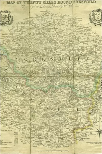
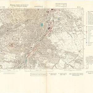
Metal Print : Map of twenty miles around Sheffield, engraved for the directory of 1852


![]()
Metal Prints from Sheffield City Archives
Map of twenty miles around Sheffield, engraved for the directory of 1852
Scale 3 miles : 1 inch.Size 41 x 34 cm.Original at Local Studies A11S
Sheffield City Archives and Local Studies Library has an unrivalled collection of images of Sheffield, England
Media ID 14047922
© Sheffield City Council
15"x10" (38x25cm) Metal Print
Discover the history of Sheffield with our stunning Metal Print of a 1852 Map from the Sheffield City Archives. This intricately detailed map, originally engraved for the directory, showcases the twenty-mile radius surrounding Sheffield. With a scale of three miles to one inch, each feature is brought to life in crisp detail. Bring a piece of local history into your home or office with this beautiful and durable Metal Print. Size not specified to allow for various framing options. Original map held at Local Studies A11S.
Your image is printed photographically and bonded to a 3.5mm thick, Dibond board (black polyethylene sandwiched between two sheets of white coated aluminium). The panel is then sealed with a gloss protective covering. Supplied complete with a wall mount which holds the print 10mm from the wall.
Made with durable metal and luxurious printing techniques, metal prints bring images to life and add a modern touch to any space
Estimated Product Size is 25.4cm x 38.1cm (10" x 15")
These are individually made so all sizes are approximate
Artwork printed orientated as per the preview above, with landscape (horizontal) or portrait (vertical) orientation to match the source image.
FEATURES IN THESE COLLECTIONS
> Maps and Charts
> Related Images
> Sheffield City Archives
> Maps and Plans
EDITORS COMMENTS
This print showcases a historical gem, the "Map of twenty miles around Sheffield" engraved specifically for the directory of 1852. With its impressive scale of 3 miles to 1 inch, this map offers an intricate and detailed representation of the region's landscape during that era. Measuring at a substantial size of 41 x 34 cm, it is truly a testament to the meticulous craftsmanship employed in its creation. Preserved within Sheffield City Archives' Local Studies collection (A11S), this remarkable piece provides us with a fascinating glimpse into the past. It allows us to explore and understand how Sheffield and its surrounding areas were structured over one and a half centuries ago. The map not only serves as an invaluable resource for historians but also captivates those with an interest in cartography or local geography. Its fine engravings depict various landmarks, roads, rivers, and settlements that once shaped this vibrant region. As we admire this print from Sheffield City Archives today, let us appreciate the dedication put forth by those who meticulously crafted such maps in earlier times. While we cannot overlook their commercial value back then – aiding businesses in navigating these lands – let us focus on appreciating it as an artifact representing our rich history rather than considering any potential commercial use it may have had.
MADE IN THE UK
Safe Shipping with 30 Day Money Back Guarantee
FREE PERSONALISATION*
We are proud to offer a range of customisation features including Personalised Captions, Color Filters and Picture Zoom Tools
SECURE PAYMENTS
We happily accept a wide range of payment options so you can pay for the things you need in the way that is most convenient for you
* Options may vary by product and licensing agreement. Zoomed Pictures can be adjusted in the Basket.


![[South] Part of the West Riding of Yorkshire, 1796](/sq/716/south-west-riding-yorkshire-1796-14047414.jpg.webp)