Metal Print > Animals > Mammals > Didelphidae > Formosa
Metal Print : WW2 - Map of China, Korea, Formosa and the southern part of


![]()
Metal Prints from Mary Evans Picture Library
WW2 - Map of China, Korea, Formosa and the southern part of
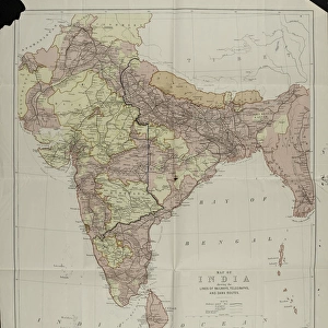
Map of China, Korea, Formosa and the southern part of Japan, 27 Mar 1944. Compiled and drawn in the Branch of Research and Analysis, oss. Subtitled: Terrain and TransportationThe map represents the highland schematically as mountains and marks railways, roads and ?selected trails? as well as the main towns. From a collection of four maps of the Far East, used by C E R Clarabut, Combined Operations, 1944-1945. Large-scale map of China, more detailed maps of Canton and Hong Kong and of the area around Chittagong in India and Burma. Date: 1944
Mary Evans Picture Library makes available wonderful images created for people to enjoy over the centuries
Media ID 14404016
© The National Army Museum / Mary Evans Picture Library
1944 Analysis Compiled Drawn Formosa Highland Korea Main Marks Railways Represents Research Roads Selected Southern Terrain Trails
15"x10" (38x25cm) Metal Print
Step back in time with our exclusive Media Storehouse Metal Print featuring a historic WW2 map. This captivating image, sourced from Mary Evans Prints Online, showcases a Rights Managed map compiled and drawn in the Branch of Research and Analysis, OSS, in March 1944. This detailed representation of China, Korea, Formosa, and the southern part of Japan provides a fascinating glimpse into the strategic landscape of the Pacific Theater during World War II. Bring history to life in your home or office with this high-quality, vibrant and durable metal print.
Your image is printed photographically and bonded to a 3.5mm thick, Dibond board (black polyethylene sandwiched between two sheets of white coated aluminium). The panel is then sealed with a gloss protective covering. Supplied complete with a wall mount which holds the print 10mm from the wall.
Made with durable metal and luxurious printing techniques, metal prints bring images to life and add a modern touch to any space
Estimated Product Size is 38.1cm x 25.4cm (15" x 10")
These are individually made so all sizes are approximate
Artwork printed orientated as per the preview above, with landscape (horizontal) or portrait (vertical) orientation to match the source image.
FEATURES IN THESE COLLECTIONS
> Animals
> Mammals
> Didelphidae
> Formosa
> Arts
> Photorealistic artworks
> Detailed art pieces
> Masterful detailing in art
> Asia
> Hong Kong
> Related Images
> Asia
> India
> Related Images
> Asia
> Japan
> Related Images
EDITORS COMMENTS
This historic map print, dated March 27, 1944, offers a detailed representation of the terrain and transportation networks in China, Korea, Formosa (Taiwan), and the southern part of Japan during World War II. Compiled and drawn in the Branch of Research and Analysis of the Office of Strategic Services (OSS), this map was an essential tool for military planning and intelligence gathering during the conflict. The map schematically depicts the highlands as mountains, providing a clear visualization of the rugged topography in the region. It also marks key transportation routes, including railways, major roads, and selected trails, enabling military strategists to plan logistical operations and assess potential supply lines. The main towns and cities are also indicated, providing valuable context for understanding the geopolitical landscape of the time. This map is part of a larger collection of four maps of the Far East, which were used by C E R Clarabut of Combined Operations between 1944 and 1945. The collection includes a large-scale map of China, as well as more detailed maps of Canton and Hong Kong and the area around Chittagong in India and Burma. The maps were crucial for planning and executing military campaigns in the region and offer a fascinating glimpse into the intelligence gathering and strategic planning efforts of the Allied forces during World War II.
MADE IN THE UK
Safe Shipping with 30 Day Money Back Guarantee
FREE PERSONALISATION*
We are proud to offer a range of customisation features including Personalised Captions, Color Filters and Picture Zoom Tools
SECURE PAYMENTS
We happily accept a wide range of payment options so you can pay for the things you need in the way that is most convenient for you
* Options may vary by product and licensing agreement. Zoomed Pictures can be adjusted in the Basket.