Metal Print > Science > Space Exploration > Planets > Earth
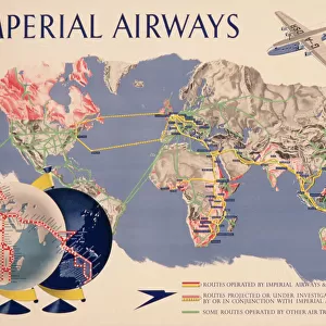
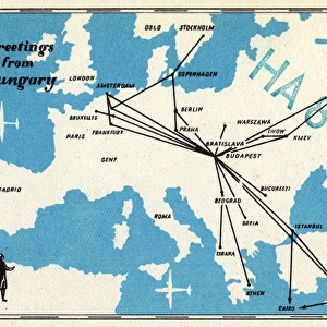
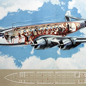
Metal Print : Route map, Imperial Airways


![]()
Metal Prints from Mary Evans Picture Library
Route map, Imperial Airways
Route map, Imperial Airways.
1938
Mary Evans Picture Library makes available wonderful images created for people to enjoy over the centuries
Media ID 14376332
© Mary Evans Picture Library/Onslow Auctions Limited
1938 Airline Airlines Airways Earth Global Globe Maps Passengers Planet Route Routes
15"x10" (38x25cm) Metal Print
Travel back in time with our stunning Metal Prints from Media Storehouse, featuring this vintage Route Map of Imperial Airways from Mary Evans Picture Library/Onslow Auctions Limited. Dated 1938, this captivating image transports you to an era of glamour and adventure in air travel. The high-quality metal print process brings out the intricate details of the map, making it a unique and eye-catching addition to any room. Relive the history of aviation and add a touch of nostalgia to your home decor with this beautiful piece.
Your image is printed photographically and bonded to a 3.5mm thick, Dibond board (black polyethylene sandwiched between two sheets of white coated aluminium). The panel is then sealed with a gloss protective covering. Supplied complete with a wall mount which holds the print 10mm from the wall.
Made with durable metal and luxurious printing techniques, metal prints bring images to life and add a modern touch to any space
Estimated Product Size is 38.1cm x 25.4cm (15" x 10")
These are individually made so all sizes are approximate
Artwork printed orientated as per the preview above, with landscape (horizontal) or portrait (vertical) orientation to match the source image.
FEATURES IN THESE COLLECTIONS
> Maps and Charts
> Related Images
> Maps and Charts
> World
> Science
> Space Exploration
> Planets
> Earth
EDITORS COMMENTS
1. Title: Imperial Airways Route Map, 1938 This vintage print showcases the extensive global reach of Imperial Airways, a pioneering British airline that revolutionized air transport during the 1930s. The map, dated 1938, illustrates the intricate network of routes that connected various corners of the world, offering a glimpse into the golden age of aviation. The map is adorned with a rich, earthy tone, evoking a sense of adventure and exploration. The intricate lines and colorful pins mark the diverse destinations served by Imperial Airways, which spanned Europe, the Middle East, Africa, India, and the Far East. The routes crisscross continents, weaving together a complex web of connections that linked distant lands and brought the world closer together. The map's design is both functional and aesthetically pleasing, with a clear and easy-to-read layout. The use of a world map as the background adds a sense of scale, emphasizing the global scope of Imperial Airways' operations. The inclusion of various points of interest, such as major cities and landmarks, further enhances the visual appeal and historical significance of the print. The 1930s were a pivotal period in the history of air travel, as advancements in technology and infrastructure made flying increasingly accessible to the masses. Imperial Airways, with its extensive network and commitment to innovation, played a crucial role in shaping the aviation industry and making the world a smaller place. This Imperial Airways Route Map, 1938, is an invaluable historical artifact that offers a fascinating glimpse into the past and the evolution of air transport. It serves as a reminder of the wonder and excitement that accompanied early air travel and the role it played in connecting people and cultures around the world.
MADE IN THE UK
Safe Shipping with 30 Day Money Back Guarantee
FREE PERSONALISATION*
We are proud to offer a range of customisation features including Personalised Captions, Color Filters and Picture Zoom Tools
SECURE PAYMENTS
We happily accept a wide range of payment options so you can pay for the things you need in the way that is most convenient for you
* Options may vary by product and licensing agreement. Zoomed Pictures can be adjusted in the Basket.