Metal Print > Animals > Birds > Passerines > Finches > Atlantic Canary
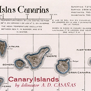
Metal Print : Map of La Palma, Canary Islands


![]()
Metal Prints from Mary Evans Picture Library
Map of La Palma, Canary Islands
Map of La Palma, Canary Islands. Date: circa 1908
Mary Evans Picture Library makes available wonderful images created for people to enjoy over the centuries
Media ID 14262716
© Mary Evans / Pharcide
Atlantic Canaries Canary Cruz Maps Palma Quisisana Tenerife
15"x10" (38x25cm) Metal Print
Discover the enchanting beauty of the Canary Islands with our stunning Metal Print of a vintage Map of La Palma. This exquisite piece, sourced from Mary Evans Prints Online, transports you back in time to circa 1908 with its intricate details and captivating design. The high-quality metal print process ensures vibrant colors and exceptional durability, making it a perfect addition to any room in your home or office. Bring a piece of the world's natural wonders into your space with this unique and eye-catching decorative piece. Order now and let the adventure begin!
Your image is printed photographically and bonded to a 3.5mm thick, Dibond board (black polyethylene sandwiched between two sheets of white coated aluminium). The panel is then sealed with a gloss protective covering. Supplied complete with a wall mount which holds the print 10mm from the wall.
Made with durable metal and luxurious printing techniques, metal prints bring images to life and add a modern touch to any space
Estimated Product Size is 25.4cm x 38.1cm (10" x 15")
These are individually made so all sizes are approximate
Artwork printed orientated as per the preview above, with landscape (horizontal) or portrait (vertical) orientation to match the source image.
FEATURES IN THESE COLLECTIONS
> Animals
> Birds
> Passerines
> Finches
> Atlantic Canary
> Animals
> Mammals
> Cricetidae
> Santa Cruz Mouse
> Animals
> Mammals
> Muridae
> Water Mouse
> Arts
> Artists
> O
> Oceanic Oceanic
> Europe
> France
> Canton
> Landes
> Maps and Charts
> Related Images
EDITORS COMMENTS
This map print, dated circa 1908, showcases the beautiful island of La Palma in the Canary Islands located in the Atlantic Ocean. The intricate details of the map reveal the various coastal towns and villages, including Santa Cruz de La Palma, the largest city and political capital, and the popular tourist destination of Quisisana, known for its Grand Hotel. The map provides a glimpse into the geography of the island, highlighting its rugged coastline, volcanic terrain, and the vast expanse of the Atlantic Ocean that surrounds it. The map also includes the neighboring islands of Tenerife, Gran Canaria, and El Hierro, adding to the grandeur of the view. The map serves as a testament to the rich history and natural beauty of the Canary Islands, which have been a popular destination for travelers since the late 1800s. The islands' unique location, situated near the intersection of the North and South Atlantic currents, offers a diverse climate and a wealth of natural resources, making it an ideal destination for exploration and relaxation. This map print is a beautiful addition to any home or office, transporting viewers to a time when travel was an adventure and the natural wonders of the world were a source of endless fascination. With its intricate details and stunning visual representation of the island, this map is a must-have for anyone with an appreciation for history, geography, or the natural world.
MADE IN THE UK
Safe Shipping with 30 Day Money Back Guarantee
FREE PERSONALISATION*
We are proud to offer a range of customisation features including Personalised Captions, Color Filters and Picture Zoom Tools
SECURE PAYMENTS
We happily accept a wide range of payment options so you can pay for the things you need in the way that is most convenient for you
* Options may vary by product and licensing agreement. Zoomed Pictures can be adjusted in the Basket.