Metal Print > Europe > United Kingdom > England > London > Museums > National Army Museum
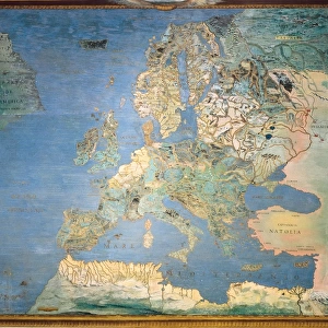
Metal Print : Map: The Invasions of England and Ireland - 1627


![]()
Metal Prints from Mary Evans Picture Library
Map: The Invasions of England and Ireland - 1627
Map: The Invasions of England and Ireland With al [sic] their Civill [sic] Wars since the Conquest Corn Danckertsz sculpsit [London] George Humble, 1627 (c). Framed hand-coloured and engraved map by John Speed. Depicts the locations of various battles, invasions and naval engagements in the British Isles since 1066, including the Wars of the Roses (1455-1485) and the Spanish Armada (1586-1588). Date: circa 1627
Mary Evans Picture Library makes available wonderful images created for people to enjoy over the centuries
Media ID 14404162
© The National Army Museum / Mary Evans Picture Library
1627 Battles Conquest Corn Depicts Engraved Framed Humble Invasions Locations Speed Wars Sculpsit
15"x10" (38x25cm) Metal Print
Discover historical depth with our Media Storehouse Metal Prints featuring the intricately detailed Map: The Invasions of England and Ireland - 1627. This captivating antique map, sourced from Mary Evans Prints Online, masterfully illustrates significant invasions and civil wars since the Conquest. Engraved by Cornelis Danckerts and published in London in 1627, this historic map is now transformed into a stunning, long-lasting metal print. Add a touch of history to your space and bring the past to life with this beautiful and informative piece.
Your image is printed photographically and bonded to a 3.5mm thick, Dibond board (black polyethylene sandwiched between two sheets of white coated aluminium). The panel is then sealed with a gloss protective covering. Supplied complete with a wall mount which holds the print 10mm from the wall.
Made with durable metal and luxurious printing techniques, metal prints bring images to life and add a modern touch to any space
Estimated Product Size is 38.1cm x 25.4cm (15" x 10")
These are individually made so all sizes are approximate
Artwork printed orientated as per the preview above, with landscape (horizontal) or portrait (vertical) orientation to match the source image.
FEATURES IN THESE COLLECTIONS
> Arts
> Artists
> S
> John Speed
> Europe
> Republic of Ireland
> Maps
> Europe
> Spain
> Related Images
> Europe
> United Kingdom
> England
> London
> Museums
> British Library
> Europe
> United Kingdom
> England
> London
> Museums
> British Museum
> Europe
> United Kingdom
> England
> London
> Museums
> National Army Museum
> Europe
> United Kingdom
> England
> London
> Sights
> British Museum
> Europe
> United Kingdom
> England
> Maps
EDITORS COMMENTS
This intricately detailed and beautifully hand-colored map, titled "The Invasions of England and Ireland with their Civil Wars since the Conquest," dates back to circa 1627. The map was created by the renowned English cartographer John Speed, with the sculpture by Cornelis Danckerts and published by George Humble in London. The map offers a comprehensive depiction of significant battles, invasions, and naval engagements that have shaped the history of England and Ireland since the Norman Conquest of 1066. The map covers the British Isles and highlights key locations such as Edinburgh, Dublin, London, and various other cities and towns. Notable historical events marked on the map include the Wars of the Roses (1455-1485), which saw the struggle for the English throne between the House of Lancaster and the House of York, and the Spanish Armada (1586-1588), a failed invasion attempt by the Spanish fleet under Philip II of Spain. The map's intricate detail and historical significance make it a valuable resource for scholars, historians, and anyone interested in the rich history of England and Ireland. The map's borders are adorned with elaborate decorative elements, and the hand-coloring adds an extra layer of visual interest. This map is a testament to the meticulous craftsmanship and historical knowledge of its creators, providing a fascinating glimpse into the past.
MADE IN THE UK
Safe Shipping with 30 Day Money Back Guarantee
FREE PERSONALISATION*
We are proud to offer a range of customisation features including Personalised Captions, Color Filters and Picture Zoom Tools
SECURE PAYMENTS
We happily accept a wide range of payment options so you can pay for the things you need in the way that is most convenient for you
* Options may vary by product and licensing agreement. Zoomed Pictures can be adjusted in the Basket.