Metal Print > Arts > Photorealistic artworks > Meticulous attention to detail > Detailed artwork
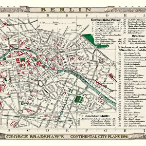
Metal Print : George Bradshaws Plan of Frankfort, Germany 1896


![]()
Metal Prints from MapSeeker
George Bradshaws Plan of Frankfort, Germany 1896
This is a detailed Plan of Frankfort showing the streets, canals, principal buildings, railways and railway stations. It has been meticulously recreated in colour and republished without and fold creases by Mapseeker, from a rare antique original black and white fold up tourist city map. The 29 that were originally published as fold up maps featuring the principal cities of Europe are now rare, yet popular at their time among those who could then explore Europe by railway for the first time
Welcome to the Mapseeker Image library and enter an historic gateway to one of the largest on-line collections of Historic Maps, Nostalgic Views, Vista's and Panorama's from a World gone by.
Media ID 20347991
© Mapseeker Publishing Ltd
Bradshaw City Map Bradshaw Map Europe City Europe City Plan European City Map European City Plan Historic Map Old Town Plan Frankfort German City
15"x10" (38x25cm) Metal Print
Discover the rich history of Frankfort, Germany with our stunning Metal Print of George Bradshaw's Plan of the city from 1896. This intricately detailed map, published by MapSeeker Publishing Ltd, showcases the streets, canals, principal buildings, railways, and railway stations of Frankfort in all its glory. Meticulously recreated in vibrant colors, this beautiful metal print brings the past to life, making it a perfect addition to any home or office. Experience the timeless charm of Frankfort's history with this exquisite piece of art.
Your image is printed photographically and bonded to a 3.5mm thick, Dibond board (black polyethylene sandwiched between two sheets of white coated aluminium). The panel is then sealed with a gloss protective covering. Supplied complete with a wall mount which holds the print 10mm from the wall.
Made with durable metal and luxurious printing techniques, metal prints bring images to life and add a modern touch to any space
Estimated Product Size is 38.1cm x 25.4cm (15" x 10")
These are individually made so all sizes are approximate
Artwork printed orientated as per the preview above, with landscape (horizontal) or portrait (vertical) orientation to match the source image.
FEATURES IN THESE COLLECTIONS
> MapSeeker
> Maps of Europe
> Maps of Germany PORTFOLIO
> Arts
> Artists
> W
> George White
> Arts
> Modern art pieces
> Pop art
> Street art
> Arts
> Photorealistic artworks
> Detailed art pieces
> Masterful detailing in art
> Arts
> Photorealistic artworks
> Meticulous attention to detail
> Detailed artwork
> Arts
> Photorealistic artworks
> Meticulous attention to detail
> Fine art
> Maps and Charts
> Related Images
EDITORS COMMENTS
This vibrant and meticulously recreated print showcases George Bradshaw's Plan of Frankfort, Germany in 1896. A true gem for history enthusiasts and map collectors alike, this detailed plan offers a glimpse into the bustling streets, canals, principal buildings, railways, and railway stations of the city. Originally published as one of the 29 fold-up maps featuring Europe's key cities, these maps were highly sought after by early railway explorers. MapSeeker has taken great care to reproduce this rare antique original without any fold creases and in vivid color. The result is a stunning piece that captures the essence of Frankfort's past. As you explore this old town plan, you'll be transported back to a time when European travel by rail was an exciting new adventure. George Bradshaw's expertise shines through in every line and detail on this historic map. It not only serves as a navigational tool but also offers a fascinating snapshot of Frankfort during its formative years. From its charming streets to its grand landmarks, immerse yourself in the rich history of this German city. Whether you're an avid collector or simply appreciate historical artifacts, this print is sure to captivate your imagination with its intricate beauty. MapSeeker Publishing Ltd takes pride in bringing these remarkable pieces back to life for all to enjoy – preserving our shared heritage one map at a time.
MADE IN THE UK
Safe Shipping with 30 Day Money Back Guarantee
FREE PERSONALISATION*
We are proud to offer a range of customisation features including Personalised Captions, Color Filters and Picture Zoom Tools
SECURE PAYMENTS
We happily accept a wide range of payment options so you can pay for the things you need in the way that is most convenient for you
* Options may vary by product and licensing agreement. Zoomed Pictures can be adjusted in the Basket.