Metal Print > Maps and Charts > Related Images
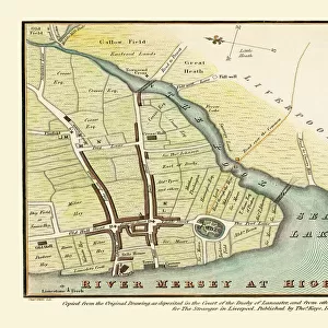
Metal Print : Old Map of Map of Liverpool Surveyed in 1795 by John Stockdale


![]()
Metal Prints from MapSeeker
Old Map of Map of Liverpool Surveyed in 1795 by John Stockdale
J016
Welcome to the Mapseeker Image library and enter an historic gateway to one of the largest on-line collections of Historic Maps, Nostalgic Views, Vista's and Panorama's from a World gone by.
Media ID 20347977
City Of Liverpool Map Historic Liverpool Map Historic Map Liverpool Liverpool City Liverpool City Map Liverpool Map Liverpool Town Plan Map Of Liverpool Old Map Of Liverpool Old Town Plan Town Plan Of Liverpool Stockdale
15"x10" (38x25cm) Metal Print
Step back in time with our exquisite Metal Print of the Old Map of Liverpool, surveyed in 1795 by John Stockdale. This captivating piece from our Media Storehouse Metal Prints collection brings history to life with stunning detail and vibrant colors. The intricate lines and markings of the map are beautifully accentuated on the sleek, durable metal surface, making it a unique and eye-catching addition to any room. Travel back in time and explore the rich history of Liverpool with this stunning piece of decor. Order yours today from MapSeeker and bring a piece of the past into your home.
Your image is printed photographically and bonded to a 3.5mm thick, Dibond board (black polyethylene sandwiched between two sheets of white coated aluminium). The panel is then sealed with a gloss protective covering. Supplied complete with a wall mount which holds the print 10mm from the wall.
Made with durable metal and luxurious printing techniques, metal prints bring images to life and add a modern touch to any space
Estimated Product Size is 38.1cm x 25.4cm (15" x 10")
These are individually made so all sizes are approximate
Artwork printed orientated as per the preview above, with landscape (horizontal) or portrait (vertical) orientation to match the source image.
FEATURES IN THESE COLLECTIONS
> MapSeeker
> British Town And City Plans
> English & Welsh PORTFOLIO
> Maps and Charts
> Related Images
EDITORS COMMENTS
This print showcases an exquisite piece of history, the "Old Map of Liverpool Surveyed in 1795" by John Stockdale. Steeped in nostalgia and charm, this map offers a fascinating glimpse into the past, allowing us to traverse the streets and alleyways of Liverpool as it stood over two centuries ago. With meticulous detail and precision, Stockdale's survey captures the essence of this bustling maritime city during its formative years. Every street, building, and landmark is meticulously depicted on this beautifully preserved town plan. From the iconic waterfront with its bustling docks to the intricate network of narrow lanes that wind through the heart of Liverpool's historic center, this map immerses us in a bygone era. As we explore this remarkable artifact, we are transported back to a time when Liverpool was rapidly evolving into one of Britain's most important trading ports. The map whispers tales of merchants haggling over goods at bustling markets while ships from around the world docked along its shores. Beyond being a mere geographical representation, this old map serves as a testament to Liverpool's rich heritage and enduring spirit. It reminds us that beneath our modern metropolis lies layers upon layers of stories waiting to be discovered. Whether you are an avid historian or simply captivated by maps' allure, allow yourself to get lost within these intricately drawn lines and immerse yourself in Liverpool's vibrant past captured forever on John Stockdale's masterful creation.
MADE IN THE UK
Safe Shipping with 30 Day Money Back Guarantee
FREE PERSONALISATION*
We are proud to offer a range of customisation features including Personalised Captions, Color Filters and Picture Zoom Tools
SECURE PAYMENTS
We happily accept a wide range of payment options so you can pay for the things you need in the way that is most convenient for you
* Options may vary by product and licensing agreement. Zoomed Pictures can be adjusted in the Basket.