Metal Print > Europe > United Kingdom > England > London > Boroughs > Ealing
Metal Print : Ealing W3 0 Map


![]()
Metal Prints from Map Marketing
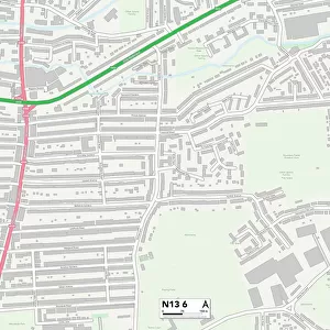
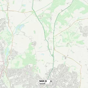
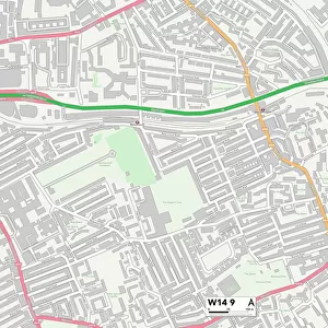
Ealing W3 0 Map
Postcode Sector Map of Ealing W3 0
Media ID 19980928
Balfour Road Canada Road Cecil Road Churchill Gardens Court Way Dukes Road Ealing Highfield Road Howard Close Kendal Avenue Links Road Lowfield Road Mansfield Road Monks Drive Norman Way Oxford Court Park View Princes Gardens Queens Drive Saxon Drive The Link Tudor Gardens Vale Lane Walton Gardens Walton Way
15"x10" (38x25cm) Metal Print
Your image is printed photographically and bonded to a 3.5mm thick, Dibond board (black polyethylene sandwiched between two sheets of white coated aluminium). The panel is then sealed with a gloss protective covering. Supplied complete with a wall mount which holds the print 10mm from the wall.
Made with durable metal and luxurious printing techniques, metal prints bring images to life and add a modern touch to any space
Estimated Product Size is 38.1cm x 25.4cm (15" x 10")
These are individually made so all sizes are approximate
Artwork printed orientated as per the preview above, with landscape (horizontal) or portrait (vertical) orientation to match the source image.
FEATURES IN THESE COLLECTIONS
> Map Marketing
> Postcode Sector Maps
> W - London W
> Map Marketing
> UK Maps
> Europe
> United Kingdom
> England
> London
> Boroughs
> Ealing
> Europe
> United Kingdom
> England
> Rutland
> Related Images
> Maps and Charts
> Related Images
> North America
> Canada
> Maps
> North America
> Canada
> Related Images
MADE IN THE UK
Safe Shipping with 30 Day Money Back Guarantee
FREE PERSONALISATION*
We are proud to offer a range of customisation features including Personalised Captions, Color Filters and Picture Zoom Tools
SECURE PAYMENTS
We happily accept a wide range of payment options so you can pay for the things you need in the way that is most convenient for you
* Options may vary by product and licensing agreement. Zoomed Pictures can be adjusted in the Basket.