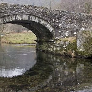
Metal Print > Europe > United Kingdom > England > London > Museums > British Library
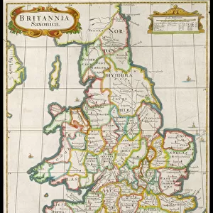
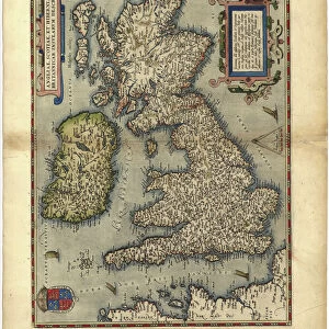
Metal Print : Matthew Pariss Map of Great Britain showing rivers & towns in the south of England & part of Wales, c. 1250 (1944)
")


![]()
Metal Prints from Heritage Images
Matthew Pariss Map of Great Britain showing rivers & towns in the south of England & part of Wales, c. 1250 (1944)
Many place-names are still recognisable today. The word Auster, written over the English Channel at the bottom, refers to wind bringing heavy cloud cover and fog. Map drawn by the historian Matthew Paris, a monk at St Albans Abbey. Cotton MS Claudius D.vi, f.12v, manuscript in the British Library, London. From " British Maps and Map-Makers", by Edward Lynam. [Collins, London, 1944]
Heritage Images features heritage image collections
Media ID 19777528
© The Print Collector/Heritage Images
Britain In Pictures Channel Coastline Collins Cornwall Dorset East Anglia Edward Edward Lynam English Channel Lynam Matthew Rivers Social History Wales William Collins William Collins And Sons William Collins Sons Wind Windy Graphic Design Matthew Paris Thirteenth Century West Country
15"x10" (38x25cm) Metal Print
Step back in time with our exquisite Media Storehouse Metal Print featuring Matthew Paris's intricately detailed Map of Great Britain from 1250 (1944). This captivating antique map showcases the rivers and towns in the south of England and part of Wales, many of which are still recognizable today. Delve into history as you trace the meandering rivers and decipher the ancient place-names. The word "Auster" written over the English Channel adds an intriguing touch, representing the wind bringing heavy cloud cover and fog. Bring this piece of history into your home and elevate your decor with our high-quality, long-lasting Metal Print.
Your image is printed photographically and bonded to a 3.5mm thick, Dibond board (black polyethylene sandwiched between two sheets of white coated aluminium). The panel is then sealed with a gloss protective covering. Supplied complete with a wall mount which holds the print 10mm from the wall.
Made with durable metal and luxurious printing techniques, metal prints bring images to life and add a modern touch to any space
Estimated Product Size is 38.1cm x 25.4cm (15" x 10")
These are individually made so all sizes are approximate
Artwork printed orientated as per the preview above, with landscape (horizontal) or portrait (vertical) orientation to match the source image.
FEATURES IN THESE COLLECTIONS
> Animals
> Mammals
> Muridae
> Fortior
> Arts
> Art Movements
> Medieval Art
> Arts
> Artists
> C
> William Collins
> Arts
> Landscape paintings
> Waterfall and river artworks
> River artworks
> Europe
> France
> Paris
> Maps
> Europe
> United Kingdom
> England
> Cornwall
> Related Images
> Europe
> United Kingdom
> England
> Dorset
> Related Images
> Europe
> United Kingdom
> England
> London
> Museums
> British Library
> Europe
> United Kingdom
> England
> London
> Weather
> Europe
> United Kingdom
> England
> Maps
EDITORS COMMENTS
This print showcases Matthew Paris' Map of Great Britain, offering a glimpse into the country's geography and history during the 13th century. Created around 1250, this medieval masterpiece reveals rivers, towns, and even weather patterns in the southern region of England and parts of Wales. The map's intricate design and vivid colors draw attention to its meticulous details. As we examine this historical artifact, it becomes apparent that many place-names depicted on the map are still recognizable today, demonstrating how some locations have retained their identity over centuries. Notably, the word "Auster" is inscribed over the English Channel at the bottom of the map, signifying wind patterns associated with heavy cloud cover and fog. Matthew Paris himself was a historian and monk at St Albans Abbey who dedicated his talents to cartography. This particular manuscript is preserved in London's British Library as Cotton MS Claudius D. vi. Its inclusion in Edward Lynam's book "British Maps and Map-Makers" further solidifies its significance within cartographic studies. The print allows us to appreciate both the artistic beauty of this medieval map as well as its valuable insights into Britain's social history. It serves as a reminder of our rich heritage while highlighting how geographical features have shaped our understanding of different regions throughout time.
MADE IN THE UK
Safe Shipping with 30 Day Money Back Guarantee
FREE PERSONALISATION*
We are proud to offer a range of customisation features including Personalised Captions, Color Filters and Picture Zoom Tools
SECURE PAYMENTS
We happily accept a wide range of payment options so you can pay for the things you need in the way that is most convenient for you
* Options may vary by product and licensing agreement. Zoomed Pictures can be adjusted in the Basket.