Metal Print > Granger Art on Demand > Maps
Metal Print : MAP OF NEW FRANCE, 1612. The westerly portion of Samuel de Champlains 1612 map


![]()
Metal Prints from Granger
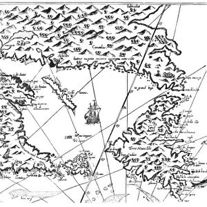
MAP OF NEW FRANCE, 1612. The westerly portion of Samuel de Champlains 1612 map
MAP OF NEW FRANCE, 1612.
The westerly portion of Samuel de Champlains 1612 map of New France
Granger holds millions of images spanning more than 25,000 years of world history, from before the Stone Age to the dawn of the Space Age
Media ID 12321104
1612 Canada Canadian Champlain Colony Detail New France Samuel
15"x10" (38x25cm) Metal Print
Discover the rich history of New France with our stunning Metal Prints featuring the westerly portion of Samuel de Champlains 1612 map. This intricately detailed map, sourced from Granger Art on Demand (140_1688001), offers a captivating glimpse into the early exploration of North America. Each Metal Print is meticulously crafted, bringing the historical cartography to life with vibrant colors and sharp contrasts. The high-quality metal surface not only enhances the visual appeal but also provides a contemporary and sleek look for your home or office decor. Transport yourself back in time and add a touch of history to your space with our beautiful and authentic Map of New France, 1612 Metal Print.
Your image is printed photographically and bonded to a 3.5mm thick, Dibond board (black polyethylene sandwiched between two sheets of white coated aluminium). The panel is then sealed with a gloss protective covering. Supplied complete with a wall mount which holds the print 10mm from the wall.
Made with durable metal and luxurious printing techniques, metal prints bring images to life and add a modern touch to any space
Estimated Product Size is 38.1cm x 25.4cm (15" x 10")
These are individually made so all sizes are approximate
Artwork printed orientated as per the preview above, with landscape (horizontal) or portrait (vertical) orientation to match the source image.
EDITORS COMMENTS
This print showcases the historical significance of Samuel de Champlain's 1612 map of New France. The intricate details and expert craftsmanship of this map transport us back to a time when Canada was still in its early stages of colonization. With a focus on the westerly portion, we can see how Champlain meticulously charted the rivers and territories that would later become integral parts of Canadian history. The map itself is a testament to the French influence in North America during this period. It highlights the French colony's expansion into new territories, as well as their exploration along various river systems. This visual representation allows us to appreciate the immense effort put forth by explorers like Champlain in mapping out uncharted lands. As we gaze upon this remarkable piece, it serves as a reminder of our rich heritage and how far we have come since those early days. It sparks curiosity about what life must have been like for settlers navigating these vast landscapes centuries ago. Granger Art on Demand has beautifully captured this significant artifact, allowing us to bring home a piece of history that continues to shape our understanding of Canada's past. Whether displayed in an educational setting or cherished within your personal collection, this print is sure to spark conversations and ignite imaginations about our nation's fascinating origins.
MADE IN THE UK
Safe Shipping with 30 Day Money Back Guarantee
FREE PERSONALISATION*
We are proud to offer a range of customisation features including Personalised Captions, Color Filters and Picture Zoom Tools
SECURE PAYMENTS
We happily accept a wide range of payment options so you can pay for the things you need in the way that is most convenient for you
* Options may vary by product and licensing agreement. Zoomed Pictures can be adjusted in the Basket.