Metal Print > Animals > Mammals > Muridae > Western Mouse
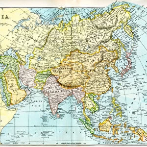
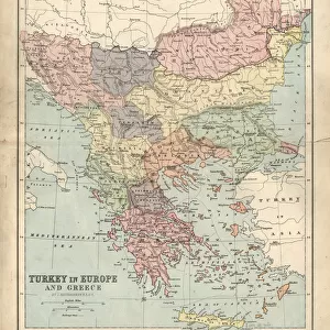
Metal Print : Vintage Map of Europe Mid 19th Century


![]()
Metal Prints from Fine Art Storehouse
Vintage Map of Europe Mid 19th Century
Vinateg Map of Europe Mid 19th Century, circa 1850
Unleash your creativity and transform your space into a visual masterpiece!
duncan1890
Media ID 13666609
© duncan1890
Central Europe Eastern Europe Geographical Locations Iberian Peninsula Iceland Illustrations And Vector Art Image Date Nordic Countries Northern Europe Past Russia Scandinavia Southern Europe Travel Locations Western Europe Image Created 19th Century Scandinavian Peninsula
20"x16" (51x41cm) Metal Print
Step back in time with our stunning Vintage Map of Europe Mid 19th Century Metal Print from the Media Storehouse Fine Art Storehouse collection. This beautifully intricate map, created circa 1850 by duncan1890, transports you to an era of exploration and discovery. The vintage map is meticulously reproduced on high-quality metal, giving it a unique and eye-catching finish. The distressed edges and subtle texture add to the authenticity of this timeless piece, making it a perfect addition to any home or office. Relive history and add a touch of vintage charm to your space with our Vintage Map of Europe Mid 19th Century Metal Print.
Your image is printed photographically and bonded to a 3.5mm thick, Dibond board (black polyethylene sandwiched between two sheets of white coated aluminium). The panel is then sealed with a gloss protective covering. Supplied complete with a wall mount which holds the print 10mm from the wall.
Made with durable metal and luxurious printing techniques, metal prints bring images to life and add a modern touch to any space
Estimated Product Size is 50.8cm x 40.6cm (20" x 16")
These are individually made so all sizes are approximate
Artwork printed orientated as per the preview above, with landscape (horizontal) or portrait (vertical) orientation to match the source image.
FEATURES IN THESE COLLECTIONS
> Fine Art Storehouse
> Map
> Historical Maps
> Fine Art Storehouse
> Map
> Italian Maps
> Animals
> Mammals
> Muridae
> Western Mouse
> Europe
> Germany
> Paintings
> Europe
> Germany
> Related Images
> Europe
> Iceland
> Paintings
EDITORS COMMENTS
This print showcases a mesmerizing "Vintage Map of Europe Mid 19th Century" taking us on a journey back in time to the year 1850. With its intricate details and exquisite engraving, this antique image captures the essence of European geography during that era. The illustration technique used in this image is truly remarkable, as it beautifully depicts the geographical locations of various countries across Europe. From Russia and Eastern Europe to Spain and Italy in Southern Europe, from Germany and Central Europe to France and the Scandinavian Peninsula - every corner of this diverse continent is meticulously illustrated. As we explore this vintage map further, we can also spot other notable regions such as the UK, Iceland, Northern Europe, Western Europe, and even the Iberian Peninsula. The past comes alive through this enchanting piece of art created almost two centuries ago. With no people present within its frame, this horizontal photograph allows us to focus solely on admiring the historical significance encapsulated within its borders. It serves as a reminder of how much our world has evolved over time while still preserving remnants of our rich cultural heritage. Whether you are an avid history enthusiast or simply appreciate fine art photography from bygone eras like the 19th century - Duncan1890's masterpiece will undoubtedly transport you into a realm where exploration meets nostalgia.
MADE IN THE UK
Safe Shipping with 30 Day Money Back Guarantee
FREE PERSONALISATION*
We are proud to offer a range of customisation features including Personalised Captions, Color Filters and Picture Zoom Tools
SECURE PAYMENTS
We happily accept a wide range of payment options so you can pay for the things you need in the way that is most convenient for you
* Options may vary by product and licensing agreement. Zoomed Pictures can be adjusted in the Basket.