Metal Print > North America > United States of America > New York > New York > Maps
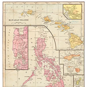
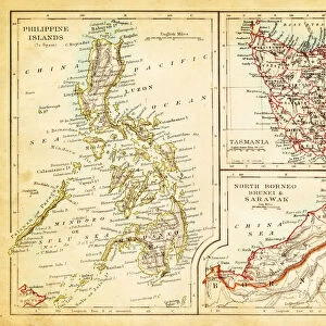
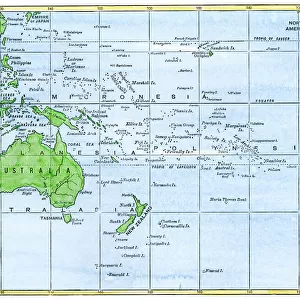
Metal Print : Philippines map 1885


![]()
Metal Prints from Fine Art Storehouse
Philippines map 1885
Encyclopedia Britannica 9th Edition New York Charles Scribners and Sons 1885 Vol XVIII
Unleash your creativity and transform your space into a visual masterpiece!
THEPALMER
Media ID 14756634
© This content is subject to copyright
Borneo Island Pacific Ocean Philippines Mindanao
15"x10" (38x25cm) Metal Print
Discover the rich history of the Philippines with our stunning Metal Print of the 1885 map from ThePalmer's "Philippine Islands and Its Dependencies" published in the Encyclopedia Britannica 9th Edition by Charles Scribner's Sons. This intricately detailed map, showcasing the Philippines during a pivotal period in its history, is now transformed into a beautiful and durable work of art. Our Metal Prints are known for their vibrant colors, crisp details, and long-lasting quality. Each print is meticulously printed on a sheet of high-quality aluminum, resulting in a sleek, modern look that adds depth and texture to any space. Bring a piece of historical cartography into your home or office with our Metal Print of the 1885 Philippines map from ThePalmer at Media Storehouse's Fine Art Storehouse.
Your image is printed photographically and bonded to a 3.5mm thick, Dibond board (black polyethylene sandwiched between two sheets of white coated aluminium). The panel is then sealed with a gloss protective covering. Supplied complete with a wall mount which holds the print 10mm from the wall.
Made with durable metal and luxurious printing techniques, metal prints bring images to life and add a modern touch to any space
Estimated Product Size is 25.4cm x 38.1cm (10" x 15")
These are individually made so all sizes are approximate
Artwork printed orientated as per the preview above, with landscape (horizontal) or portrait (vertical) orientation to match the source image.
FEATURES IN THESE COLLECTIONS
> Fine Art Storehouse
> Map
> Historical Maps
> Arts
> Artists
> O
> Oceanic Oceanic
> Asia
> Philippines
> Maps
> Asia
> Philippines
> Related Images
> Maps and Charts
> Related Images
> North America
> United States of America
> New York
> New York
> Maps
> North America
> United States of America
> New York
> Related Images
EDITORS COMMENTS
This print titled "Philippines map 1885" takes us on a journey back in time to the late 19th century. The image showcases an intricately detailed map of the Philippines, sourced from the esteemed Encyclopedia Britannica's 9th Edition published by Charles Scribners and Sons in New York in 1885. The map offers a glimpse into the geographical landscape of this archipelago nation, highlighting significant landmarks such as Borneo, Mindanao, and the vast Pacific Ocean that surrounds it. Its vintage charm is evident through its aged appearance and delicate lines that trace each island's contours. As we delve deeper into this historical artifact captured by THEPALMER, we are transported to an era when cartography was both artistry and science. This piece not only serves as a visual representation of Philippine geography but also acts as a window into cultural heritage and exploration during that period. With its rich hues and meticulous craftsmanship, this print from Fine Art Storehouse becomes more than just an aesthetic addition to any space; it becomes an educational tool bridging past and present. It invites viewers to appreciate the beauty of our world while igniting curiosity about how these lands have evolved over time. Whether displayed in homes or offices, this remarkable artwork sparks conversations about history, geography, and human progress – reminding us all of our interconnectedness with the past.
MADE IN THE UK
Safe Shipping with 30 Day Money Back Guarantee
FREE PERSONALISATION*
We are proud to offer a range of customisation features including Personalised Captions, Color Filters and Picture Zoom Tools
SECURE PAYMENTS
We happily accept a wide range of payment options so you can pay for the things you need in the way that is most convenient for you
* Options may vary by product and licensing agreement. Zoomed Pictures can be adjusted in the Basket.