Metal Print > North America > Puerto Rico > Maps
Metal Print : Cuba Puerto Rico map 1898


![]()
Metal Prints from Fine Art Storehouse
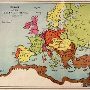
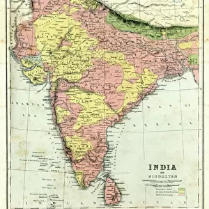
Cuba Puerto Rico map 1898
Map from Physical Geography by R. S. Tarr - The MacMillan Company - London 1898
Unleash your creativity and transform your space into a visual masterpiece!
THEPALMER
Media ID 20773193
15"x10" (38x25cm) Metal Print
Discover the rich history of Cuba and Puerto Rico with our stunning Metal Print of the 1898 Cuba Puerto Rico map by THEPALMER from the Media Storehouse Fine Art Storehouse collection. This intricately detailed map, originally published in R.S. Tarr's Physical Geography by The MacMillan Company in London, showcases the geography and political boundaries of the two islands during a pivotal moment in their history. The high-quality Metal Print process brings out the vibrant colors and textures of the map, making it a beautiful and educational addition to any home or office. Bring a piece of historical cartography into your space and transport yourself back in time with this captivating piece.
Your image is printed photographically and bonded to a 3.5mm thick, Dibond board (black polyethylene sandwiched between two sheets of white coated aluminium). The panel is then sealed with a gloss protective covering. Supplied complete with a wall mount which holds the print 10mm from the wall.
Made with durable metal and luxurious printing techniques, metal prints bring images to life and add a modern touch to any space
Estimated Product Size is 38.1cm x 25.4cm (15" x 10")
These are individually made so all sizes are approximate
Artwork printed orientated as per the preview above, with landscape (horizontal) or portrait (vertical) orientation to match the source image.
FEATURES IN THESE COLLECTIONS
> Europe
> United Kingdom
> England
> London
> Related Images
> Maps and Charts
> Related Images
> North America
> Cuba
> Maps
> North America
> Cuba
> Related Images
> North America
> Puerto Rico
> Maps
> North America
> Puerto Rico
> Related Images
EDITORS COMMENTS
This print showcases a historical gem, the Cuba Puerto Rico map from 1898. A true testament to the intricate artistry of cartography, this piece was originally featured in "Physical Geography" by R. S. Tarr and published by The MacMillan Company in London during that same year. With its rich colors and meticulous details, this map takes us back to an era when these two vibrant Caribbean islands were under Spanish rule. The artist behind this remarkable reproduction is none other than THEPALMER, whose expertise in capturing the essence of vintage maps shines through every brushstroke. This particular print captures our attention with its impeccable quality and undeniable charm. As we gaze upon this historic treasure, we are transported to a time when Cuba and Puerto Rico were at the crossroads of colonial powers vying for control over their territories. It serves as a reminder of their shared history while also highlighting their unique geographical features. Whether you're an avid collector or simply appreciate the beauty of antique maps, this fine art print is sure to captivate your imagination. Display it proudly on your wall or gift it to someone who shares your passion for history and exploration. Let yourself be enchanted by the allure of yesteryears with this exquisite Cuba Puerto Rico map from 1898 brought to life by THEPALMER's artistic prowess.
MADE IN THE UK
Safe Shipping with 30 Day Money Back Guarantee
FREE PERSONALISATION*
We are proud to offer a range of customisation features including Personalised Captions, Color Filters and Picture Zoom Tools
SECURE PAYMENTS
We happily accept a wide range of payment options so you can pay for the things you need in the way that is most convenient for you
* Options may vary by product and licensing agreement. Zoomed Pictures can be adjusted in the Basket.