Metal Print > Europe > France > Paris > Maps
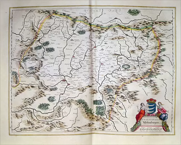
Metal Print : Map of Transylvania, from an atlas, Amsterdam, 1657 (coloured engraving)
")


![]()
Metal Prints from Fine Art Finder
Map of Transylvania, from an atlas, Amsterdam, 1657 (coloured engraving)
CHT184785 Map of Transylvania, from an atlas, Amsterdam, 1657 (coloured engraving) by Dutch School, (17th century); Bibliotheque des Arts Decoratifs, Paris, France; eArchives Charmet; Dutch, out of copyright
Media ID 22917650
© Archives Charmet / Bridgeman Images
Eastern Europe Mountain Range Romania
20"x16" (51x41cm) Metal Print
Step back in time with our exquisite Metal Prints featuring the vintage Map of Transylvania from an atlas, Amsterdam, 1657. This beautifully detailed, coloured engraving by the Dutch School showcases the historical cartography of the region as it appeared over 350 years ago. Each Metal Print is meticulously crafted to bring out the rich colours and intricate lines of this rare and fascinating map, making it a unique addition to your home or office decor. With its antique charm and modern, durable metal finish, this Map of Transylvania Metal Print is not just a piece of art, but a window into history.
Your image is printed photographically and bonded to a 3.5mm thick, Dibond board (black polyethylene sandwiched between two sheets of white coated aluminium). The panel is then sealed with a gloss protective covering. Supplied complete with a wall mount which holds the print 10mm from the wall.
Made with durable metal and luxurious printing techniques, metal prints bring images to life and add a modern touch to any space
Estimated Product Size is 50.8cm x 40.6cm (20" x 16")
These are individually made so all sizes are approximate
Artwork printed orientated as per the preview above, with landscape (horizontal) or portrait (vertical) orientation to match the source image.
FEATURES IN THESE COLLECTIONS
> Fine Art Finder
> Artists
> Dutch School
> Fine Art Finder
> Artists
> Egyptian 6th Dynasty
> Fine Art Finder
> Maps (celestial & Terrestrial)
> Europe
> France
> Paris
> Maps
> Europe
> Romania
> Related Images
> Maps and Charts
> Related Images
EDITORS COMMENTS
This print showcases a beautifully detailed "Map of Transylvania" from an atlas dating back to 1657. Created by the Dutch School in Amsterdam, this coloured engraving offers a glimpse into the rich history and geography of Eastern Europe. The map features intricate illustrations of coat of arms, mountain ranges, and various landmarks that define the region. Transylvania, known for its mystique and folklore, is brought to life through this vintage artwork. The mountains depicted on the map evoke a sense of awe and grandeur, perfectly capturing the rugged beauty of Romania's landscape. Displayed at Bibliotheque des Arts Decoratifs in Paris, France, this historical gem now finds itself preserved within eArchives Charmet. Its inclusion in Bridgeman Images' collection allows art enthusiasts worldwide to appreciate its significance without any commercial restrictions. As we admire this remarkable piece, we are transported back in time to an era when cartography was both an art form and a scientific endeavor. This map serves as a testament to human curiosity and exploration during the 17th century. Whether you have an affinity for history or simply appreciate fine craftsmanship, this Map of Transylvania print is sure to captivate your imagination with its intricate details and timeless charm.
MADE IN THE UK
Safe Shipping with 30 Day Money Back Guarantee
FREE PERSONALISATION*
We are proud to offer a range of customisation features including Personalised Captions, Color Filters and Picture Zoom Tools
SECURE PAYMENTS
We happily accept a wide range of payment options so you can pay for the things you need in the way that is most convenient for you
* Options may vary by product and licensing agreement. Zoomed Pictures can be adjusted in the Basket.