Metal Print > Fine Art Finder > Maps (celestial & Terrestrial)
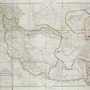
Metal Print : Persia, Georgia and Independent Tartary, from Atlas de Toutes les Parties Connues


![]()
Metal Prints from Fine Art Finder
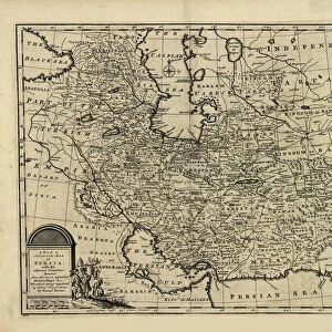
Persia, Georgia and Independent Tartary, from Atlas de Toutes les Parties Connues
KW206609 Persia, Georgia and Independent Tartary, from Atlas de Toutes les Parties Connues du Globe Terrestre by Guillaume Raynal (1713-96) published 1780 (coloured engraving) by Bonne, Charles Marie Rigobert (1727-95); Private Collection; Ken Welsh; French, out of copyright
Media ID 12755757
© www.bridgemanimages.com
Afghanistan Bhutan Caspian Sea Iran Kyrgyzstan Northern India Pakistan Tibet Turkmenistan Uzbekistan Tajikistan
15"x10" (38x25cm) Metal Print
Discover the rich history and culture of Persia, Georgia, and Independent Tartary with our stunning Metal Prints from the Atlas de Toutes les Parties Connues by Guillaume Raynal. This captivating image, sourced from Bridgeman Images and available through Fine Art Finder (KW206609), showcases the intricate details of these historic regions in a new light. Our high-quality Metal Prints are not only visually striking but also durable, ensuring your artwork remains a conversation starter for years to come. Bring a piece of the past into your home or office and transport yourself to a time of exploration and discovery with this beautiful, coloured engraving from 1780.
Your image is printed photographically and bonded to a 3.5mm thick, Dibond board (black polyethylene sandwiched between two sheets of white coated aluminium). The panel is then sealed with a gloss protective covering. Supplied complete with a wall mount which holds the print 10mm from the wall.
Made with durable metal and luxurious printing techniques, metal prints bring images to life and add a modern touch to any space
Estimated Product Size is 38.1cm x 25.4cm (15" x 10")
These are individually made so all sizes are approximate
Artwork printed orientated as per the preview above, with landscape (horizontal) or portrait (vertical) orientation to match the source image.
FEATURES IN THESE COLLECTIONS
> Fine Art Finder
> Artists
> Charles Marie Rigobert Bonne
> Fine Art Finder
> Maps (celestial & Terrestrial)
EDITORS COMMENTS
This print showcases a historical map titled "Persia, Georgia and Independent Tartary" from the renowned Atlas de Toutes les Parties Connues du Globe Terrestre by Guillaume Raynal. Published in 1780, this coloured engraving offers a fascinating glimpse into the geographical knowledge of that era. The intricate details on this map transport us to a time when Persia (modern-day Iran) held great significance as a regional power. The Caspian Sea dominates the center of the image, surrounded by neighboring countries such as Afghanistan, Pakistan, and Northern India. Further eastward lies Tibet, Bhutan, China, Tajikistan, Kyrgyzstan, Turkmenistan, and Uzbekistan - all forming part of what was then known as Independent Tartary. With its rich colors and precise engravings highlighting mountain ranges and rivers crisscrossing vast territories across Asia and the Middle East; this print is truly an artistic masterpiece. It serves not only as a visual representation but also as a testament to humanity's thirst for exploration and understanding of our world. As we gaze upon this remarkable piece from Fine Art Finder's private collection curated by Ken Welsh; we are reminded of how far cartography has come since its creation over two centuries ago. This photograph invites us to appreciate both the beauty inherent in ancient maps while acknowledging their limitations compared to today's advanced technology-driven mapping systems.
MADE IN THE UK
Safe Shipping with 30 Day Money Back Guarantee
FREE PERSONALISATION*
We are proud to offer a range of customisation features including Personalised Captions, Color Filters and Picture Zoom Tools
SECURE PAYMENTS
We happily accept a wide range of payment options so you can pay for the things you need in the way that is most convenient for you
* Options may vary by product and licensing agreement. Zoomed Pictures can be adjusted in the Basket.