Home > Arts > Artists > M > Gerardus Mercator
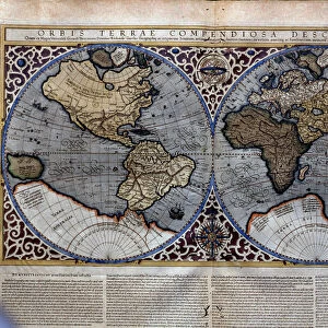
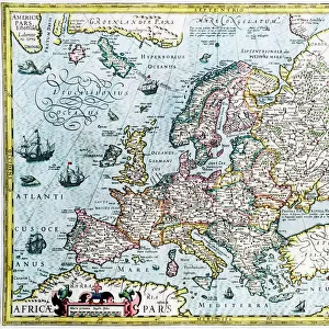
Map of the Americas1633 Date: 1633

![]()
Wall Art and Photo Gifts from Mary Evans Picture Library
Map of the Americas1633 Date: 1633
Mary Evans Picture Library makes available wonderful images created for people to enjoy over the centuries
Media ID 20184198
© The Pictures Now Image Collection / Bubblepunk
Antiquarian Antique Appears Australis Circle Continent Fills Gerardus Imaginary Journey Journeys Maps Mercator Smaller Spheres Terra Travels Treks Trip Trips Voyage Voyages
FEATURES IN THESE COLLECTIONS
> Animals
> Mammals
> Cricetidae
> Australis
> Animals
> Mammals
> Delphinidae
> Australis
> Animals
> Mammals
> Molossidae
> Australis
> Arts
> Artists
> M
> Gerardus Mercator
> Maps and Charts
> Gerardus Mercator's Cartographic
> Mary Evans Prints Online
> Pictures Now
> North America
> United States of America
> Maps
EDITORS COMMENTS
This antique map, titled "America" and dated 1633, offers a fascinating glimpse into the early European understanding of the American continents. Created by the renowned cartographer Gerardus Mercator or one of his associates, this map represents a significant moment in the history of cartography. The map, known as "America1633" or "Ofs1633," is a testament to the exploratory spirit of the 17th century. The map's intricate detailing showcases the known lands of the Americas, with North and South America clearly defined, and the Caribbean islands meticulously charted. The map also includes an imaginary southern continent, "Terra Australis," which was believed to balance the hemispheres. The map is particularly noteworthy for its use of two spheres, one for the northern hemisphere and the other for the southern. These spheres serve to highlight the geographical knowledge of the time and the cartographer's efforts to accurately represent the world. The map also features a circle that appears to represent a journey or a series of journeys, possibly indicating significant trade routes or exploratory expeditions. Despite its age, the map remains an impressive piece of cartographic art. Its intricate detailing and accurate representation of known lands make it an invaluable resource for historians, geographers, and anyone interested in the history of exploration. This map transports us back in time, allowing us to imagine the journeys and discoveries that once filled the blank spaces on the map. Whether you're an armchair explorer or a seasoned traveler, this antique map is sure to inspire a sense of wonder and curiosity about the world and its rich history.
MADE IN THE UK
Safe Shipping with 30 Day Money Back Guarantee
FREE PERSONALISATION*
We are proud to offer a range of customisation features including Personalised Captions, Color Filters and Picture Zoom Tools
SECURE PAYMENTS
We happily accept a wide range of payment options so you can pay for the things you need in the way that is most convenient for you
* Options may vary by product and licensing agreement. Zoomed Pictures can be adjusted in the Basket.