Home > Europe > Portugal > Maps
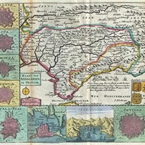
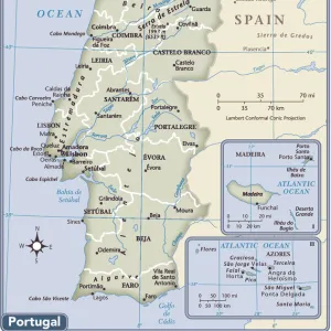
An Ottoman map of the Iberian Peninsula

![]()
Wall Art and Photo Gifts from Mary Evans Picture Library
An Ottoman map of the Iberian Peninsula
An Ottoman map of the Iberian Peninsula Date: circa 1890s
Mary Evans Picture Library makes available wonderful images created for people to enjoy over the centuries
Media ID 14376928
© Mary Evans / Grenville Collins Postcard Collection
Chart Dec15 Gibraltar Iberia Iberian Peninsula Plan Portugal Portuguese Scale Script Ottoman
FEATURES IN THESE COLLECTIONS
> Maps and Charts
> Spain
EDITORS COMMENTS
1. Title: "An Ottoman Map of the Iberian Peninsula: A Glimpse into the Past" This antique map print, hailing from the late 1890s, showcases the Iberian Peninsula as it was perceived by the Ottoman Empire during that era. The map, adorned with intricate cartographic details and rich decorative elements, reflects the historical significance of the region and the Ottoman Empire's geopolitical interests. The Iberian Peninsula, located in the southwestern Europe, is depicted with remarkable accuracy for the time, with Spain and Portugal clearly distinguished. The Ottoman cartographers have meticulously charted the coastlines, major rivers, and mountain ranges, providing a detailed representation of the geography of the region. The map's script and text are written in Ottoman Turkish, reflecting the linguistic and cultural influences of the Ottoman Empire. The key, located at the bottom right corner, includes symbols for various geographical features, such as mountains, rivers, and cities. The scale bar, located at the bottom left corner, indicates the map's scale, allowing for a better understanding of the relative size of the depicted areas. The map also features the strategic locations of Gibraltar and Ceuta, two important territories that were under Ottoman control during this period. These territories, located on the southern tip of the Iberian Peninsula, were essential for the Ottoman Empire's maritime trade and military presence in the Mediterranean. This Ottoman map of the Iberian Peninsula offers a fascinating glimpse into the past, providing insights into the historical relationships between the Ottoman Empire and the Iberian region. It serves as a reminder of the complex and intriguing history that connects these two distinct civilizations.
MADE IN THE UK
Safe Shipping with 30 Day Money Back Guarantee
FREE PERSONALISATION*
We are proud to offer a range of customisation features including Personalised Captions, Color Filters and Picture Zoom Tools
SECURE PAYMENTS
We happily accept a wide range of payment options so you can pay for the things you need in the way that is most convenient for you
* Options may vary by product and licensing agreement. Zoomed Pictures can be adjusted in the Basket.