Home > Europe > United Kingdom > England > London > Towns > Newington
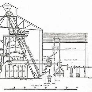
1832 Victorian Map of Southwark

![]()
Wall Art and Photo Gifts from Mary Evans Picture Library
1832 Victorian Map of Southwark
Mary Evans Picture Library makes available wonderful images created for people to enjoy over the centuries
Media ID 32351958
© The Keasbury-Gordon Photograph Archive / Mary Evans
1832 Borough Boroughs Boundaries Boundary Constituencies Constituency Newington Parliament Parliamentary Reform Southwark
FEATURES IN THESE COLLECTIONS
> Europe
> United Kingdom
> England
> London
> Boroughs
> Southwark
> Europe
> United Kingdom
> England
> London
> Towns
> Newington
> Europe
> United Kingdom
> England
> Maps
> Maps and Charts
> Early Maps
> Mary Evans Prints Online
> New Images July 2023
EDITORS COMMENTS
This stunning print captures a piece of history with the 1832 Victorian Map of Southwark. The intricate details and craftsmanship of this vintage map showcase the boundaries and constituencies of the parliamentary boroughs in London, England during the early Victorian era.
As you gaze upon this Edwardian-era map, you can almost imagine yourself walking through the streets of Southwark, exploring its bustling neighborhoods and vibrant communities. The careful delineation of each constituency gives insight into the political landscape of the time, highlighting the importance of representation and governance in shaping society.
The use of lantern slides to project this map would have been a common practice in educational settings or public lectures, allowing audiences to engage with geography and politics in a visually stimulating way. This particular map likely played a role in discussions surrounding electoral reform and parliamentary acts during its time.
Whether you are a history buff, cartography enthusiast, or simply appreciate fine artistry from bygone eras, this 1832 Victorian Map of Southwark is sure to captivate your imagination and transport you back to a pivotal moment in London's past. It serves as a reminder that even old maps hold valuable insights into our shared heritage and collective identity.
MADE IN THE UK
Safe Shipping with 30 Day Money Back Guarantee
FREE PERSONALISATION*
We are proud to offer a range of customisation features including Personalised Captions, Color Filters and Picture Zoom Tools
SECURE PAYMENTS
We happily accept a wide range of payment options so you can pay for the things you need in the way that is most convenient for you
* Options may vary by product and licensing agreement. Zoomed Pictures can be adjusted in the Basket.