Home > Europe > Netherlands > Maps
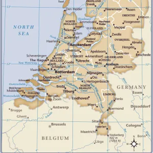
Map of Low Countries by G. H. Davis

![]()
Wall Art and Photo Gifts from Mary Evans Picture Library
Map of Low Countries by G. H. Davis
Defence by inundation: the Low Countries bar against invasion. A pictorial map drawn in the early weeks of the Second World War, showing the main zones in Holland and Belgium which would be flooded should an emergency arise.
1939
Mary Evans Picture Library makes available wonderful images created for people to enjoy over the centuries
Media ID 14132279
© Illustrated London News Ltd/Mary Evans
Belgian Countries Davis Defence Emergency Flooded Flooding Holland Inundation Invasion Netherlands Pictorial Zone Zones
FEATURES IN THESE COLLECTIONS
> Europe
> Netherlands
> Maps
> Maps and Charts
> Early Maps
> Maps and Charts
> Netherlands
> Maps and Charts
> World
EDITORS COMMENTS
This evocative map, titled "Defence by Inundation: The Low Countries Bar Against Invasion," was created by renowned cartographer G.H. Davis in the early weeks of World War II, around 1939. The map provides a unique insight into the strategic defensive measures employed by the Netherlands and Belgium during this tumultuous period. The Low Countries, comprising modern-day Netherlands and Belgium, were particularly vulnerable to invasion due to their geographical location. The map illustrates the main zones in these countries that would be flooded in case of an emergency. The flooding was intended to create a barrier against potential invaders, a tactic known as the "Dutch Water Line." The map is a pictorial representation of the Netherlands and Belgium, with various cities, towns, and waterways depicted. The North Sea and the Zuider Zee (Southern Sea) are also shown, emphasizing the importance of these bodies of water in the defense strategy. The map was produced during the late 1930s, a time of heightened tension and fear of invasion. The Second World War had already begun in Europe, and the Low Countries were bracing themselves for potential conflict. The map serves as a testament to the resilience and innovative defense strategies employed by these nations during this period. The intricate details and meticulous attention to detail in the map reflect Davis' expertise as a cartographer. The map's historical significance makes it an essential addition to any collection focusing on World War II, European history, or military strategy. This map is an important reminder of the strategic measures taken during wartime to protect against invasion and the role that geography and water played in shaping defense strategies. The map's visual appeal and historical significance make it a captivating and informative addition to any space.
MADE IN THE UK
Safe Shipping with 30 Day Money Back Guarantee
FREE PERSONALISATION*
We are proud to offer a range of customisation features including Personalised Captions, Color Filters and Picture Zoom Tools
SECURE PAYMENTS
We happily accept a wide range of payment options so you can pay for the things you need in the way that is most convenient for you
* Options may vary by product and licensing agreement. Zoomed Pictures can be adjusted in the Basket.