Home > Europe > United Kingdom > Scotland > Edinburgh > Edinburgh
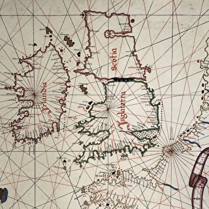
A map of Britain, mid 16th century

![]()
Wall Art and Photo Gifts from Mary Evans Picture Library
A map of Britain, mid 16th century
A map of Britain in the mid 16th century, detailing Edinburgh, Dover, Cornwall, Waterford and London. Date: Mid 16th century
Mary Evans Picture Library makes available wonderful images created for people to enjoy over the centuries
Media ID 14221391
© Mary Evans Picture Library
1550s Dover Edinburgh Hibernia Places Scotia Waterford
FEATURES IN THESE COLLECTIONS
> Europe
> Republic of Ireland
> Maps
> Europe
> Republic of Ireland
> Waterford
> Europe
> United Kingdom
> England
> Cornwall
> Related Images
> Europe
> United Kingdom
> England
> London
> Related Images
> Europe
> United Kingdom
> England
> Maps
> Europe
> United Kingdom
> Scotland
> Edinburgh
> Edinburgh
> Europe
> United Kingdom
> Scotland
> Edinburgh
> Europe
> United Kingdom
> Scotland
> Lothian
> Edinburgh
> Europe
> United Kingdom
> Scotland
> Maps
> Europe
> United Kingdom
> Wales
> Maps
EDITORS COMMENTS
1. Title: "Exploring the Past: A Glimpse into Britain's Rich History through a Mid-16th Century Map" This map print, hailing from the mid-16th century, offers a fascinating glimpse into the geographical knowledge and cartographic skills of the time. The map meticulously details various regions of Britain, including Scotland, England, Wales, and Ireland, with a particular focus on Edinburgh, Dover, Cornwall, Waterford, and London. During the 1550s, as Europe was undergoing the Renaissance, cartography was also experiencing a revolution. Maps became more detailed and accurate, reflecting the growing interest in exploration and the expanding reach of European empires. This map, with its intricate depiction of the British Isles, is a testament to this era of cartographic innovation. Edinburgh, the capital city of Scotland, is shown nestled in the southeastern part of the country, while Dover, the easternmost point of England, is clearly marked. Cornwall, the most southwesterly part of England, is also visible, as is Waterford, an important Irish port city. London, the political and cultural heart of England, is prominently displayed in the southeastern part of the map. The map also includes the names of other significant places, such as Hibernia (Ireland) and Scotia (Scotland), reflecting the historical understanding of the British Isles. This map not only provides valuable insights into the geography of the time but also serves as a reminder of the rich history and cultural connections that bind the various regions of Britain. As we explore the intricacies of this map, we are transported back to the 16th century, a time of discovery, innovation, and the beginning of the modern world. This map is not just a historical artifact but a window into the past, inviting us to delve deeper into the stories and secrets that lie hidden within its lines and contours.
MADE IN THE UK
Safe Shipping with 30 Day Money Back Guarantee
FREE PERSONALISATION*
We are proud to offer a range of customisation features including Personalised Captions, Color Filters and Picture Zoom Tools
FREE COLORIZATION SERVICE
You can choose advanced AI Colorization for this picture at no extra charge!
SECURE PAYMENTS
We happily accept a wide range of payment options so you can pay for the things you need in the way that is most convenient for you
* Options may vary by product and licensing agreement. Zoomed Pictures can be adjusted in the Basket.