Home > Africa > Ethiopia (Abyssinia) > Maps
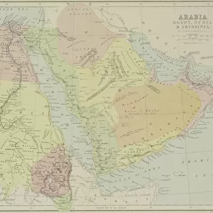
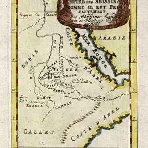
Poster Print : Map / Africa / Ethiopia 18C


![]()
Poster Prints from Mary Evans Picture Library
Map / Africa / Ethiopia 18C
Map of Ethiopia (Abyssinia)
Mary Evans Picture Library makes available wonderful images created for people to enjoy over the centuries
Media ID 608767
© Mary Evans Picture Library 2015 - https://copyrighthub.org/s0/hub1/creation/maryevans/MaryEvansPictureID/10113842
A1 (84.1 x 59.4cm) Poster Print
Discover the rich history and culture of Ethiopia with our stunning Map / Africa / Ethiopia 18C print from Mary Evans Picture Library. This exquisite poster, part of the Media Storehouse collection, transports you back in time to the 18th century with an intricately detailed map of Ethiopia, also known as Abyssinia. The vibrant and captivating image, sourced from Mary Evans Prints Online, makes for a beautiful addition to any home or office, igniting conversations about the fascinating history of this ancient African nation. Embrace the allure of the past and bring a piece of history into your space with our Map / Africa / Ethiopia 18C poster print.
A1 Poster (84.1 x 59.4cm, 33.1" x 23.4" inches) printed on 170gsm Satin Poster Paper. Securely packaged, rolled and inserted into a strong mailing tube and shipped tracked. Poster Prints are of comparable archival quality to our Photographic prints, they are simply printed on thinner Poster Paper. Whilst we only use Photographic Prints in our frames, you can frame Poster Prints if they are carefully supported to prevent sagging over time.
Poster prints are budget friendly enlarged prints in standard poster paper sizes (A0, A1, A2, A3 etc). Whilst poster paper is sometimes thinner and less durable than our other paper types, they are still ok for framing and should last many years. Our Archival Quality Photo Prints and Fine Art Paper Prints are printed on higher quality paper and the choice of which largely depends on your budget.
Estimated Product Size is 59.4cm x 84.1cm (23.4" x 33.1")
These are individually made so all sizes are approximate
Artwork printed orientated as per the preview above, with portrait (vertical) orientation to match the source image.
FEATURES IN THESE COLLECTIONS
> Africa
> Ethiopia (Abyssinia)
> Maps
> Africa
> Ethiopia (Abyssinia)
> Related Images
> Africa
> Ethiopia
> Related Images
> Maps and Charts
> Early Maps
EDITORS COMMENTS
This historic map print, titled "Abyssinia or Ethiopia in Africa," dates back to the early 18th century, specifically 1719. The map provides a fascinating glimpse into the geographical knowledge of Ethiopia and the Horn of Africa during this period. Ethiopia, also known as Abyssinia, is depicted with intricate detail, showcasing its various provinces, rivers, and mountains. The map was created during a time when European exploration and cartography were advancing rapidly, yet Ethiopia remained largely unknown to the Western world. This map, therefore, reflects the limited information available about the region at the time. The cartographer's understanding of the geography of Ethiopia was influenced by ancient Greek and Roman texts, as well as accounts from travelers and missionaries. Despite the inaccuracies and misconceptions present in the map, it remains an important historical document. The map's depiction of Ethiopia as a powerful and independent kingdom, rather than a European colony, reflects the reality of the region's political status during this era. Ethiopia was one of the few African states that successfully resisted European colonization, maintaining its sovereignty throughout the 19th century. The map also highlights the significance of Ethiopia as a center of Christianity in Africa. The Ethiopian Orthodox Church, which traces its origins back to the 4th century, is the oldest independent Christian church in the world. The map shows various Christian sites and regions within Ethiopia, reflecting the deep religious history of the country. Overall, this map print offers a captivating window into the history of Ethiopia and the Horn of Africa during the 18th century. Its intricate details and historical significance make it an essential addition to any collection of historical maps or African studies.
MADE IN THE UK
Safe Shipping with 30 Day Money Back Guarantee
FREE PERSONALISATION*
We are proud to offer a range of customisation features including Personalised Captions, Color Filters and Picture Zoom Tools
SECURE PAYMENTS
We happily accept a wide range of payment options so you can pay for the things you need in the way that is most convenient for you
* Options may vary by product and licensing agreement. Zoomed Pictures can be adjusted in the Basket.