Home > Europe > Belgium > Maps
Holland, Belgium and part of Germany. Map

![]()
Wall Art and Photo Gifts from Mary Evans Picture Library
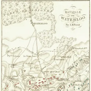
Holland, Belgium and part of Germany. Map
Holland, Belgium and part of Germany. Map. Made by Michaelis Tramezini, 1558. Printed by Iacobus Bossius
Mary Evans Picture Library makes available wonderful images created for people to enjoy over the centuries
Media ID 14337041
© Thaliastock / Mary Evans
1558 Cartography Holland Mapping Michaelis
FEATURES IN THESE COLLECTIONS
> Maps and Charts
> Early Maps
EDITORS COMMENTS
This intriguing map print, created by the renowned cartographer Michaelis Tramezini in 1558 and printed by Iacobus Bossius, offers a fascinating glimpse into the geographical knowledge of Europe during the 16th century. The map depicts the regions of Holland, Belgium, and a portion of Germany, providing a historical perspective on the political and geographical boundaries of the time. The map, titled "Nova et exactissima totius Belgicae, Germaniae Inferioris, et Circini Partis Descriptio," reveals a meticulously detailed representation of the territories, with various cities, rivers, and topographical features accurately marked. The intricate cartography showcases the advanced skills of Tramezini and Bossius, who were pioneers in the field of mapmaking during the modern age. The map's historical significance lies in its portrayal of the European landscape during the late Renaissance period. At this time, the territories of Holland and Belgium were undergoing significant political changes, with the rise of the Spanish Habsburgs and the Dutch Revolt. This map offers a snapshot of the region before the tumultuous events that would shape its future. Furthermore, the map serves as an essential resource for understanding the historical context of the European mapmaking tradition. Tramezini and Bossius' work represents a crucial step in the development of accurate and detailed maps, paving the way for more comprehensive and precise cartographic representations in the centuries to come. In conclusion, this map print of Holland, Belgium, and part of Germany, created by Michaelis Tramezini and printed by Iacobus Bossius in 1558, is an invaluable historical artifact that offers insights into the geographical knowledge and cartographic techniques of the 16th century. Its intricate details and historical significance make it an essential addition to any collection focused on European history, cartography, or geography.
MADE IN THE UK
Safe Shipping with 30 Day Money Back Guarantee
FREE PERSONALISATION*
We are proud to offer a range of customisation features including Personalised Captions, Color Filters and Picture Zoom Tools
SECURE PAYMENTS
We happily accept a wide range of payment options so you can pay for the things you need in the way that is most convenient for you
* Options may vary by product and licensing agreement. Zoomed Pictures can be adjusted in the Basket.