Home > Europe > United Kingdom > Scotland > Dumfries and Galloway > Wigtown
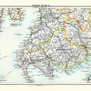
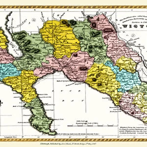
Old County Map of Wigtown Scotland 1847 by A&C Black

![]()
Wall Art and Photo Gifts from MapSeeker
Old County Map of Wigtown Scotland 1847 by A&C Black
A finely detailed facimile remastered in full colour from an antique original map of Wigtownshire featured in A&C Blacks Atlas of 1847. Each Parish is numbered using an index table, colour rendition beautifully differentiating all of the Parishes. As well as principal roads, towns, villages and hamlets, these county maps of Scotland feature key battle sites marked with two crossed swords and the date of the battle
Welcome to the Mapseeker Image library and enter an historic gateway to one of the largest on-line collections of Historic Maps, Nostalgic Views, Vista's and Panorama's from a World gone by.
Media ID 20347642
© Mapseeker Publishing Ltd
A And C Black A And C Black Atlas A And C Black Map County Map County Map Of Scotland Historic Map Old County Map Old Scottish County Map Scottish County Map Wigtown Wigtownshire
FEATURES IN THESE COLLECTIONS
> Arts
> Photorealistic artworks
> Detailed art pieces
> Masterful detailing in art
> Europe
> United Kingdom
> Scotland
> Dumfries and Galloway
> Wigtown
> Europe
> United Kingdom
> Scotland
> Maps
> Europe
> United Kingdom
> Scotland
> Wigtownshire
> Maps and Charts
> Early Maps
> Maps and Charts
> Related Images
> MapSeeker
> Maps from the British Isles
> Scotland and Counties PORTFOLIO
EDITORS COMMENTS
Step back in time with this exquisite print of the "Old County Map of Wigtown, Scotland 1847" by A&C Black. Remastered in full color from an antique original map featured in A&C Blacks Atlas of 1847, this finely detailed facsimile captures the essence and charm of historic Wigtownshire. Every parish is meticulously numbered using an index table, allowing you to easily navigate through the region's rich history. The vibrant color rendition beautifully differentiates each parish, bringing to life the diverse landscapes and communities that once thrived within these borders. Not only does this map showcase principal roads, towns, villages, and hamlets, but it also highlights key battle sites with two crossed swords and their respective dates. These markers serve as a poignant reminder of the struggles faced by those who came before us and add a layer of historical significance to this already remarkable piece. Transport yourself to a bygone era as you explore every intricate detail on this old Scottish county map. Whether you have ancestral ties to Wigtown or simply appreciate its storied past, this historic map will undoubtedly become a cherished addition to your collection. Embrace the allure of Wigtownshire's heritage with this extraordinary print – a testament to both A&C Black's craftsmanship and Scotland's enduring legacy.
MADE IN THE UK
Safe Shipping with 30 Day Money Back Guarantee
FREE PERSONALISATION*
We are proud to offer a range of customisation features including Personalised Captions, Color Filters and Picture Zoom Tools
SECURE PAYMENTS
We happily accept a wide range of payment options so you can pay for the things you need in the way that is most convenient for you
* Options may vary by product and licensing agreement. Zoomed Pictures can be adjusted in the Basket.