Home > Europe > United Kingdom > Scotland > West Lothian > Linlithgow
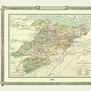
Old County Map of Linlithgow Scotland 1847 by A&C Black

![]()
Wall Art and Photo Gifts from MapSeeker
Old County Map of Linlithgow Scotland 1847 by A&C Black
A finely detailed facimile remastered in full colour from an antique original map of Linlithgow featured in A&C Blacks Atlas of 1847. Each Parish is numbered using an index table, colour rendition beautifully differentiating all of the Parishes. As well as principal roads, towns, villages and hamlets, these county maps of Scotland feature key battle sites marked with two crossed swords and the date of the battle
Welcome to the Mapseeker Image library and enter an historic gateway to one of the largest on-line collections of Historic Maps, Nostalgic Views, Vista's and Panorama's from a World gone by.
Media ID 20347602
© Mapseeker Publishing Ltd
A And C Black A And C Black Atlas A And C Black Map County Map County Map Of Scotland Historic Map Old County Map Old Scottish County Map Scottish County Map Linlithgow Linlithgowshire
FEATURES IN THESE COLLECTIONS
> Arts
> Photorealistic artworks
> Detailed art pieces
> Masterful detailing in art
> Europe
> United Kingdom
> Scotland
> Linlithgowshire
> Europe
> United Kingdom
> Scotland
> Lothian
> Linlithgow
> Europe
> United Kingdom
> Scotland
> Maps
> Europe
> United Kingdom
> Scotland
> West Lothian
> Linlithgow
> Maps and Charts
> Early Maps
> Maps and Charts
> Related Images
> MapSeeker
> Maps from the British Isles
> Scotland and Counties PORTFOLIO
EDITORS COMMENTS
This beautifully remastered print of the "Old County Map of Linlithgow Scotland 1847" by A&C Black is a true treasure for history enthusiasts and map collectors alike. The level of detail in this full-color facsimile is simply astounding, allowing us to explore the rich tapestry of Linlithgow's past. The map showcases each Parish with numbered markers, making it easy to navigate through the region. What truly sets this piece apart is its exquisite color rendition, which artfully differentiates all of the Parishes. As we trace our fingers along principal roads, towns, villages, and hamlets on this historic Scottish county map, we can't help but be transported back in time. One notable feature that adds depth to this already remarkable map is the inclusion of key battle sites marked with two crossed swords and their respective dates. These reminders serve as poignant symbols of Scotland's tumultuous history and pay homage to those who fought bravely on these grounds. Whether you're a proud Scot or simply fascinated by cartography and history, this old county map offers a captivating glimpse into Linlithgowshire's heritage. Hung proudly on any wall or carefully studied up close, it serves as both an educational tool and a stunning work of art
MADE IN THE UK
Safe Shipping with 30 Day Money Back Guarantee
FREE PERSONALISATION*
We are proud to offer a range of customisation features including Personalised Captions, Color Filters and Picture Zoom Tools
SECURE PAYMENTS
We happily accept a wide range of payment options so you can pay for the things you need in the way that is most convenient for you
* Options may vary by product and licensing agreement. Zoomed Pictures can be adjusted in the Basket.