Home > Arts > Artists > S > John Speed
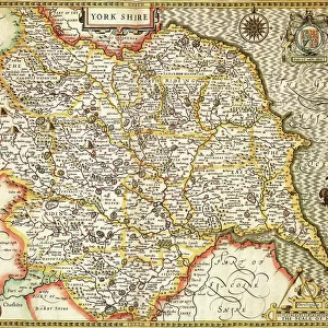
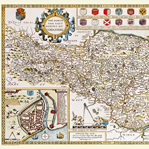
Yorkshire North & East Riding Historical John Speed 1610 Map

![]()
Wall Art and Photo Gifts from Map Marketing
Yorkshire North & East Riding Historical John Speed 1610 Map
A reproduction of John Speeds historical map of the county of North Yorkshire & the East Riding. Originally published as part of his atlas called The Theatre of the Empire of Great Britain in 1610. John Speed ((1552-1629) was a renowned English cartographer, his maps themselves were of high quality and gained a great reputation for being among the best county maps
Media ID 19950629
© Map Marketing Ltd
1610 Historical Map John Speed North Yorkshire East Riding East Yorkshire North Riding
FEATURES IN THESE COLLECTIONS
> Arts
> Artists
> S
> John Speed
> Europe
> United Kingdom
> England
> East Riding of Yorkshire
> Related Images
> Europe
> United Kingdom
> England
> North Yorkshire
> Related Images
> Europe
> United Kingdom
> England
> Yorkshire
> Related Images
> Maps and Charts
> British Empire Maps
> Maps and Charts
> Early Maps
> Maps and Charts
> Related Images
MADE IN THE UK
Safe Shipping with 30 Day Money Back Guarantee
FREE PERSONALISATION*
We are proud to offer a range of customisation features including Personalised Captions, Color Filters and Picture Zoom Tools
SECURE PAYMENTS
We happily accept a wide range of payment options so you can pay for the things you need in the way that is most convenient for you
* Options may vary by product and licensing agreement. Zoomed Pictures can be adjusted in the Basket.