Home > Europe > United Kingdom > Wales > Powys > Montgomery
Sutton SM2 5 Map

![]()
Wall Art and Photo Gifts from Map Marketing
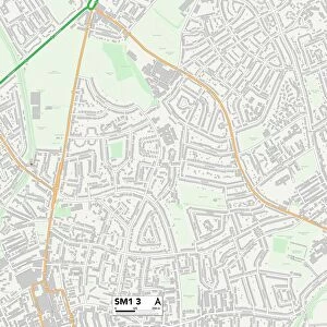
Sutton SM2 5 Map
Postcode Sector Map of Sutton SM2 5
Media ID 19981610
Albion Road Ambleside Gardens Autumn Drive Baron Close Bassett Close Belmont Brighton Road Cavendish Road Cedar Gardens Cedar Road Chelmsford Close Cheviot Close Chiltern Road Clifton Avenue Coniston Gardens Copse Hill Cotswold Road Crossways Devonshire Avenue Devonshire Road Downs Road Eaton Road Egmont Road Farm Close Farm Road Ferndown Close Filey Close Grampian Close Hatfield Close Heath Drive Kingswood Drive Madison Close Mayfield Road Milestone Close Mitre Close Rutherford Close Sinclair Drive Station Approach Sutton Sutton Lane The Causeway The Highway The Quadrant Upland Road Wellesley Road White Lodge Close
FEATURES IN THESE COLLECTIONS
> Animals
> Mammals
> Muridae
> Heath Mouse
> Europe
> United Kingdom
> Wales
> Powys
> Montgomery
> Map Marketing
> Postcode Sector Maps
> SM - Sutton
> Maps and Charts
> Related Images
MADE IN THE UK
Safe Shipping with 30 Day Money Back Guarantee
FREE PERSONALISATION*
We are proud to offer a range of customisation features including Personalised Captions, Color Filters and Picture Zoom Tools
SECURE PAYMENTS
We happily accept a wide range of payment options so you can pay for the things you need in the way that is most convenient for you
* Options may vary by product and licensing agreement. Zoomed Pictures can be adjusted in the Basket.