Home > Europe > United Kingdom > England > London > Boroughs > Havering
Havering RM14 3 Map

![]()
Wall Art and Photo Gifts from Map Marketing
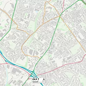
Havering RM14 3 Map
Postcode Sector Map of Havering RM14 3
Media ID 19979024
Albert Road Ashleigh Gardens Boyd Close Brentwood Road Canterbury Avenue Cedar Gardens Chester Avenue Church Lane Church Road Coniston Avenue Fairfield Avenue Fen Lane Foxhall Road Greenbanks Harrow Lane Harrow Road Havering Meadow Way Meadowside Road Park Drive Peartree Lane Pike Lane Rectory Gardens Springfield Gardens St Albans Avenue St Marys Lane Stanley Road The Chase The Glade The Meads The Shrubbery Tudor Gardens Victoria Road Winchester Avenue Worcester Avenue
FEATURES IN THESE COLLECTIONS
> Europe
> United Kingdom
> England
> London
> Boroughs
> Harrow
> Europe
> United Kingdom
> England
> London
> Boroughs
> Havering
> Europe
> United Kingdom
> England
> London
> Sights
> Victoria Park
> Map Marketing
> Postcode Sector Maps
> RM - Romford
> Maps and Charts
> Related Images
MADE IN THE UK
Safe Shipping with 30 Day Money Back Guarantee
FREE PERSONALISATION*
We are proud to offer a range of customisation features including Personalised Captions, Color Filters and Picture Zoom Tools
SECURE PAYMENTS
We happily accept a wide range of payment options so you can pay for the things you need in the way that is most convenient for you
* Options may vary by product and licensing agreement. Zoomed Pictures can be adjusted in the Basket.