Home > Europe > United Kingdom > England > London > Boroughs > Hackney
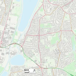
Hackney E10 7 Map

![]()
Wall Art and Photo Gifts from Map Marketing
Hackney E10 7 Map
Postcode Sector Map of Hackney E10 7
Media ID 19970207
Albany Road Amberley Road Baird Close Belvedere Road Cambrian Road Church Road Connaught Close Dunton Road Elm Park Road Gloucester Road Grange Road Hackney Lammas Road Manor Road Marsh Lane Meadow Close Melbourne Road Norton Road Overton Road Park Road Perth Road Queens Drive Riverside Close Russell Road Seymour Road Sunnyside Road Waterloo Road Wellington Road Westerham Road Lea Bridge
FEATURES IN THESE COLLECTIONS
> Europe
> Malta
> Related Images
> Europe
> United Kingdom
> England
> London
> Boroughs
> Hackney
> Map Marketing
> Postcode Sector Maps
> E - London E
> Maps and Charts
> Malta
> Maps and Charts
> Related Images
MADE IN THE UK
Safe Shipping with 30 Day Money Back Guarantee
FREE PERSONALISATION*
We are proud to offer a range of customisation features including Personalised Captions, Color Filters and Picture Zoom Tools
SECURE PAYMENTS
We happily accept a wide range of payment options so you can pay for the things you need in the way that is most convenient for you
* Options may vary by product and licensing agreement. Zoomed Pictures can be adjusted in the Basket.