Home > Europe > United Kingdom > England > London > Boroughs > Bromley
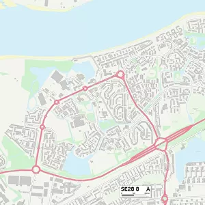
Bromley SE26 6 Map

![]()
Wall Art and Photo Gifts from Map Marketing
Bromley SE26 6 Map
Postcode Sector Map of Bromley SE26 6
Media ID 19981818
Bluebell Close Border Road Bradford Close Bromley Chestnut Place Coombe Road Dallas Road Hall Drive Hillcrest Close Mill Gardens Plane Street Prospect Close Rock Hill Springfield Rise Springfield Road Taylors Lane The Martins
FEATURES IN THESE COLLECTIONS
> Arts
> Portraits
> Pop art gallery
> Street art portraits
> Europe
> United Kingdom
> England
> London
> Boroughs
> Bromley
> Map Marketing
> Postcode Sector Maps
> SE - London SE
> Maps and Charts
> Related Images
MADE IN THE UK
Safe Shipping with 30 Day Money Back Guarantee
FREE PERSONALISATION*
We are proud to offer a range of customisation features including Personalised Captions, Color Filters and Picture Zoom Tools
SECURE PAYMENTS
We happily accept a wide range of payment options so you can pay for the things you need in the way that is most convenient for you
* Options may vary by product and licensing agreement. Zoomed Pictures can be adjusted in the Basket.


![LNER Southern Area Leeds District - Adjustment of Curve between Cullingworth and Ingrow - 201m 10ch to 201m 70ch [1934]](/sq/229/lner-southern-area-leeds-district-adjustment-10820716.jpg.webp)