Home > Europe > United Kingdom > England > Birmingham > Area > Hall Green
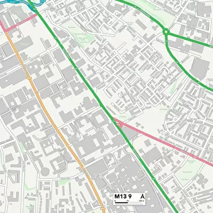
Birmingham B28 9 Map

![]()
Wall Art and Photo Gifts from Map Marketing
Birmingham B28 9 Map
Postcode Sector Map of Birmingham B28 9
Media ID 19965375
Beechcroft Avenue Birmingham Brampton Avenue Coniston Close Delamere Road Ferndale Road Green Court Gresham Road Hall Green Hamlet Road Mapleton Road Overton Close Pembroke Way Rowan Drive Sleaford Road Southfield Drive Stanley Close Staplehurst Road Temple Avenue Wellfield Road
FEATURES IN THESE COLLECTIONS
> Europe
> United Kingdom
> England
> Birmingham
> Area
> Hall Green
> Europe
> United Kingdom
> England
> Birmingham
> Area
> Solihull
> Europe
> United Kingdom
> Wales
> Pembrokeshire
> Pembroke
> Map Marketing
> Postcode Sector Maps
> B - Birmingham
> Maps and Charts
> Related Images
MADE IN THE UK
Safe Shipping with 30 Day Money Back Guarantee
FREE PERSONALISATION*
We are proud to offer a range of customisation features including Personalised Captions, Color Filters and Picture Zoom Tools
SECURE PAYMENTS
We happily accept a wide range of payment options so you can pay for the things you need in the way that is most convenient for you
* Options may vary by product and licensing agreement. Zoomed Pictures can be adjusted in the Basket.