Jigsaw Puzzle > Universal Images Group (UIG) > Art > Painting, Sculpture & Prints > Cartography
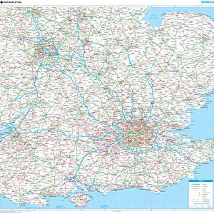
Jigsaw Puzzle : Map of Senegal, Mauritania and Gambia, 1729


![]()
Jigsaw Puzzles from Universal Images Group (UIG)
Map of Senegal, Mauritania and Gambia, 1729
Cartography, 18th century. Map of Senegal, Mauritania and Gambia, 1729
Universal Images Group (UIG) manages distribution for many leading specialist agencies worldwide
Media ID 9504737
© DEA / M. SEEMULLER
18th Century Africa Coastline Gambia Guidance Mauritania Senegal Western Script
Jigsaw Puzzle (400 Pieces)
Discover the rich history and cultural wonders of West Africa with the Media Storehouse Jigsaw Puzzle featuring the intricately detailed map of Senegal, Mauritania, and Gambia from 1729. This captivating puzzle, based on an original 18th-century map from Universal Images Group, invites you on an adventure as you piece together the borders of these fascinating countries. Explore the intricacies of the map's cartography, delve into the history of the region, and enjoy the satisfaction of completing a beautiful and educational puzzle. Perfect for history enthusiasts, puzzle lovers, and anyone seeking a captivating and challenging pastime.
400 piece puzzles are custom made in the UK and hand-finished on 100% recycled 1.5 mm millboard. There is a level of repetition in jigsaw shapes with each matching piece away from its pair. The completed puzzle measures 31x47cm and is delivered packaged in an attractive presentation box specially designed to fit most letter box slots
Jigsaw Puzzles are an ideal gift for any occasion
Estimated Product Size is 31.5cm x 47.2cm (12.4" x 18.6")
These are individually made so all sizes are approximate
Artwork printed orientated as per the preview above, with landscape (horizontal) or portrait (vertical) orientation to match the source image.
EDITORS COMMENTS
This print showcases a remarkable piece of cartographic history - the Map of Senegal, Mauritania, and Gambia from 1729. Crafted in the 18th century, this intricate map offers a fascinating glimpse into the exploration and navigation techniques of that era. Its vertical orientation allows for an immersive experience as one delves into the rich details depicted on its surface. The map serves as a valuable guide to understanding the geography and coastline of these African regions during this time period. With Western script elegantly inscribed across its expanse, it provides essential information for sailors and explorers venturing through these treacherous waters. The illustration and painting techniques employed in creating this masterpiece are truly awe-inspiring. Intriguingly devoid of people, this historical artifact focuses solely on presenting an accurate representation of the landmasses it portrays. As we gaze upon it today, we can't help but marvel at how far our knowledge has come since those early days of maritime exploration. This photograph print by Universal Images Group (UIG) not only captures the essence of this ancient map but also invites us to delve deeper into Africa's past. It sparks curiosity about the journeys undertaken by brave adventurers who relied on such maps to navigate uncharted territories. A true testament to human ingenuity and thirst for discovery, this image is a treasure trove for history enthusiasts seeking insight into Africa's coastal landscapes centuries ago.
MADE IN THE UK
Safe Shipping with 30 Day Money Back Guarantee
FREE PERSONALISATION*
We are proud to offer a range of customisation features including Personalised Captions, Color Filters and Picture Zoom Tools
SECURE PAYMENTS
We happily accept a wide range of payment options so you can pay for the things you need in the way that is most convenient for you
* Options may vary by product and licensing agreement. Zoomed Pictures can be adjusted in the Basket.