Jigsaw Puzzle : World Map / Crates Mallos


![]()
Jigsaw Puzzles from Mary Evans Picture Library
World Map / Crates Mallos
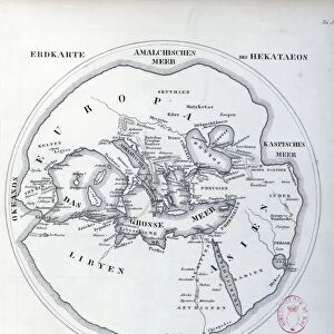
A world map according to Crates of Mallos, showing Europe, Libya, the Antipodes, and various seas Date: circa 168 BC
Mary Evans Picture Library makes available wonderful images created for people to enjoy over the centuries
Media ID 7124621
© Mary Evans Picture Library 2015 - https://copyrighthub.org/s0/hub1/creation/maryevans/MaryEvansPictureID/10113657
Antipodes Crates Libya Maps Seas Mallos
Jigsaw Puzzle (500 Pieces)
Discover the fascination of ancient cartography with our Media Storehouse Jigsaw Puzzle featuring the World Map from Crates Mallos. This captivating puzzle, derived from an image by Rights Managed from Mary Evans Prints Online, offers a glimpse into the intriguing world of ancient geography. Dating back to circa 168 BC, this map showcases Europe, Libya, the Antipodes, and various seas as they were understood during that time. Piece together this historical puzzle and embark on an educational adventure, unlocking the mysteries of the ancient world one puzzle piece at a time.
500 piece puzzles are custom made in the UK and hand-finished on 100% recycled 1.5 mm millboard. There is a level of repetition in jigsaw shapes with each matching piece away from its pair. The completed puzzle measures 38x50cm and is delivered packaged in an attractive presentation box specially designed to fit most letter box slots
Jigsaw Puzzles are an ideal gift for any occasion
Estimated Product Size is 38cm x 50.2cm (15" x 19.8")
These are individually made so all sizes are approximate
Artwork printed orientated as per the preview above, with landscape (horizontal) or portrait (vertical) orientation to match the source image.
EDITORS COMMENTS
This intriguing world map, dated circa 168 BC, is based on the descriptions of the ancient Greek philosopher and geographer Crates of Mallos. The map depicts the known world as it was understood during the Hellenistic period, with a focus on Europe, Libya, and the Antipodes. Crates of Mallos was a renowned scholar from Pergamon in Asia Minor, who is believed to have lived around the second century BC. He is best known for his contributions to geography and cartography, having written several works on the subject. This map, which is one of the earliest surviving examples of a world map from the ancient world, is based on his descriptions. The map shows Europe in its entirety, with the Mediterranean Sea to the south and the Atlantic Ocean to the west. To the south, the African continent is depicted as Libya, with the Nile River running through it. The Red Sea and the Indian Ocean are also shown, with the Antipodes, or the lands located on the opposite side of the world, indicated in the southern hemisphere. The map is notable for its accurate depiction of the Mediterranean Sea and the Black Sea, as well as the correct placement of the Iberian Peninsula and the British Isles. It also shows the location of several ancient cities, such as Rome, Carthage, and Alexandria. Despite its age and the limitations of the technology available at the time, this map is a remarkable testament to the intellectual curiosity and cartographic skills of the ancient world. It offers a fascinating glimpse into the geographical knowledge of the time and the ways in which the ancient Greeks and Romans understood the world around them.
MADE IN THE UK
Safe Shipping with 30 Day Money Back Guarantee
FREE PERSONALISATION*
We are proud to offer a range of customisation features including Personalised Captions, Color Filters and Picture Zoom Tools
SECURE PAYMENTS
We happily accept a wide range of payment options so you can pay for the things you need in the way that is most convenient for you
* Options may vary by product and licensing agreement. Zoomed Pictures can be adjusted in the Basket.