Jigsaw Puzzle > Europe > United Kingdom > England > Huntingdonshire
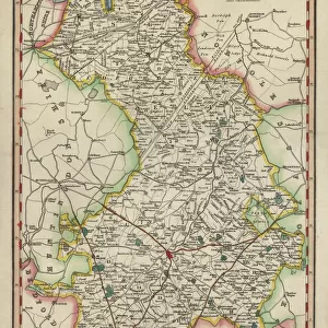
Jigsaw Puzzle : Map / Huntingdonshire 1810


![]()
Jigsaw Puzzles from Mary Evans Picture Library
Map / Huntingdonshire 1810
Map of Huntingdonshire
Mary Evans Picture Library makes available wonderful images created for people to enjoy over the centuries
Media ID 573980
© Mary Evans Picture Library 2015 - https://copyrighthub.org/s0/hub1/creation/maryevans/MaryEvansPictureID/10009512
Jigsaw Puzzle (500 Pieces)
Discover the captivating world of history with our exquisite collection of jigsaw puzzles from Media Storehouse. This stunning puzzle, featuring the "Map of Huntingdonshire 1810" by Mary Evans Picture Library from Mary Evans Prints Online, invites you on an adventure through time. Marvel at the intricate details and vibrant colors as you piece together this beautiful map of Huntingdonshire from 1810. Each puzzle piece fits seamlessly into its intended place, providing a satisfying sense of accomplishment with every connection. Immerse yourself in the past, and bring history to life, one puzzle piece at a time.
500 piece puzzles are custom made in the UK and hand-finished on 100% recycled 1.5 mm millboard. There is a level of repetition in jigsaw shapes with each matching piece away from its pair. The completed puzzle measures 38x50cm and is delivered packaged in an attractive presentation box specially designed to fit most letter box slots
Jigsaw Puzzles are an ideal gift for any occasion
Estimated Product Size is 50.2cm x 38cm (19.8" x 15")
These are individually made so all sizes are approximate
Artwork printed orientated as per the preview above, with landscape (horizontal) or portrait (vertical) orientation to match the source image.
FEATURES IN THESE COLLECTIONS
> Europe
> United Kingdom
> England
> Huntingdonshire
> Europe
> United Kingdom
> England
> Maps
> Europe
> United Kingdom
> England
> Posters
> Europe
> United Kingdom
> England
> Related Images
> Maps and Charts
> Early Maps
> Maps and Charts
> Related Images
EDITORS COMMENTS
This stunning print captures a piece of history with the Map of Huntingdonshire from 1810. The intricate details and delicate lines on this map provide a glimpse into the past, showcasing the geography and boundaries of Huntingdonshire in England during that time period.
As we study this historical map, we can imagine what life was like in Huntingdonshire over two centuries ago. From small villages to sprawling countryside, this map gives us insight into how the land was divided and utilized by its inhabitants. It serves as a valuable resource for historians and enthusiasts alike who are interested in exploring the evolution of this region.
The craftsmanship and artistry evident in this map remind us of a time when cartography was both practical and beautiful. Each stroke of ink represents hours of meticulous work by skilled hands, creating a visual masterpiece that stands the test of time.
Whether you have personal ties to Huntingdonshire or simply appreciate historical artifacts, this Map of Huntingdonshire from 1810 is sure to captivate your imagination. Display it proudly in your home or office as a conversation piece that sparks curiosity about our shared past.
MADE IN THE UK
Safe Shipping with 30 Day Money Back Guarantee
FREE PERSONALISATION*
We are proud to offer a range of customisation features including Personalised Captions, Color Filters and Picture Zoom Tools
SECURE PAYMENTS
We happily accept a wide range of payment options so you can pay for the things you need in the way that is most convenient for you
* Options may vary by product and licensing agreement. Zoomed Pictures can be adjusted in the Basket.