Jigsaw Puzzle > Maps and Charts > Africa
Jigsaw Puzzle : Map of the Old Continent (Europe, Africa, Asia)
")
")


![]()
Jigsaw Puzzles from Mary Evans Picture Library
Map of the Old Continent (Europe, Africa, Asia)
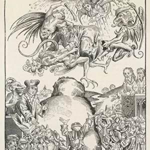
Map of the Old Continent (Europe, Africa, Asia). Engraving by J. vander Schley, from Pierre de Hondt, Histoire Naturelle generale et particuliere avec la description du Cabinet du Roy. Frontispiece to first discourse ( premier discours ). Date: 1750
Mary Evans Picture Library makes available wonderful images created for people to enjoy over the centuries
Media ID 10290395
© Mary Evans Picture Library 2015 - https://copyrighthub.org/s0/hub1/creation/maryevans/MaryEvansPictureID/10972047
1750 Avec Cabinet Continent Description Discourse Frontispiece Generale Histoire Hondt Naturelle Particuliere Pierre Premier Schley Vander Discours
Jigsaw Puzzle (500 Pieces)
Discover the wonders of the Old Continent with our captivating jigsaw puzzle from Media Storehouse. This intricately detailed puzzle showcases an enchanting map of Europe, Africa, and Asia, as depicted in the historic engraving by J. vander Schley from Pierre de Hondt's "Histoire Naturelle generale et particuliere avec la description du Cabinet du Roy." Journey through the diverse landscapes, cultures, and geography of three continents as you piece together this beautiful puzzle. Ideal for puzzle enthusiasts, history buffs, and anyone seeking an engaging and educational activity. Immerse yourself in this captivating puzzle experience and unleash your inner explorer.
500 piece puzzles are custom made in the UK and hand-finished on 100% recycled 1.5 mm millboard. There is a level of repetition in jigsaw shapes with each matching piece away from its pair. The completed puzzle measures 38x50cm and is delivered packaged in an attractive presentation box specially designed to fit most letter box slots
Jigsaw Puzzles are an ideal gift for any occasion
Estimated Product Size is 38cm x 50.2cm (15" x 19.8")
These are individually made so all sizes are approximate
Artwork printed orientated as per the preview above, with landscape (horizontal) or portrait (vertical) orientation to match the source image.
FEATURES IN THESE COLLECTIONS
> Africa
> Related Images
> Asia
> Related Images
> Europe
> Related Images
> Maps and Charts
> Related Images
> Mary Evans Prints Online
> The John Innes Centre
EDITORS COMMENTS
This stunning engraving, titled "Map of the Old Continent (Europe, Africa, Asia)" is a captivating representation of the world as known in the mid-18th century. The intricately detailed map, created by J. vander Schley for Pierre de Hondt's "Histoire Naturelle générale et particulière avec la description du Cabinet du Roy," serves as the frontispiece to the first discourse of this comprehensive natural history publication. Published in 1750, this map showcases Europe, Africa, and Asia in their entirety, providing a glimpse into the geographical knowledge of the time. The Old World is depicted with remarkable accuracy, considering the limitations of cartographic technology during the period. The intricate detailing of coastlines, borders, and topographical features is a testament to the skill and dedication of the engraver. The map is particularly noteworthy for its depiction of Africa, which was still largely unexplored and misunderstood by Europeans during this time. The map includes various speculations about the interior of the continent, reflecting the fascination and curiosity that drove European explorers to venture into the unknown. This map is a fascinating window into the past, offering insights into the geographical knowledge and perceptions of the Old World during the 18th century. Its intricate detailing and historical significance make it a valuable addition to any collection of historical maps or natural history publications.
MADE IN THE UK
Safe Shipping with 30 Day Money Back Guarantee
FREE PERSONALISATION*
We are proud to offer a range of customisation features including Personalised Captions, Color Filters and Picture Zoom Tools
SECURE PAYMENTS
We happily accept a wide range of payment options so you can pay for the things you need in the way that is most convenient for you
* Options may vary by product and licensing agreement. Zoomed Pictures can be adjusted in the Basket.