Jigsaw Puzzle > Europe > United Kingdom > Wales > Maps
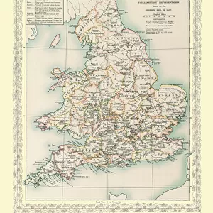
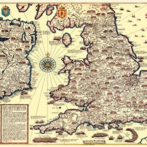
Jigsaw Puzzle : Map of England and Wales as it appeared in the Reign of Edward I


![]()
Jigsaw Puzzles from MapSeeker
Map of England and Wales as it appeared in the Reign of Edward I
BHISM004
Welcome to the Mapseeker Image library and enter an historic gateway to one of the largest on-line collections of Historic Maps, Nostalgic Views, Vista's and Panorama's from a World gone by.
Media ID 20348187
Jigsaw Puzzle (500 Pieces)
Discover the rich history of England and Wales with the Media Storehouse BHISM004 Jigsaw Puzzle featuring a captivating Map of England and Wales as it appeared during the reign of Edward I, reproduced from the MapSeeker collection. This intricately detailed puzzle is an excellent way to engage your mind and transport yourself back in time. With countless hours of enjoyable assembly, this historical puzzle is perfect for history enthusiasts, puzzle lovers, or anyone seeking a challenging and rewarding pastime. Immerse yourself in the intricacies of this beautiful map and bring a piece of the past into your home.
500 piece puzzles are custom made in the UK and hand-finished on 100% recycled 1.5 mm millboard. There is a level of repetition in jigsaw shapes with each matching piece away from its pair. The completed puzzle measures 38x50cm and is delivered packaged in an attractive presentation box specially designed to fit most letter box slots
Jigsaw Puzzles are an ideal gift for any occasion
Estimated Product Size is 38cm x 50.2cm (15" x 19.8")
These are individually made so all sizes are approximate
Artwork printed orientated as per the preview above, with landscape (horizontal) or portrait (vertical) orientation to match the source image.
FEATURES IN THESE COLLECTIONS
> Europe
> United Kingdom
> England
> Maps
> Europe
> United Kingdom
> Wales
> Maps
> Europe
> United Kingdom
> Wales
> Posters
> Europe
> United Kingdom
> Wales
> Related Images
> Maps and Charts
> Related Images
> Maps and Charts
> Wales
> MapSeeker
> Maps from the British Isles
> England with Wales PORTFOLIO
EDITORS COMMENTS
This print showcases a historical treasure, the "Map of England and Wales as it appeared in the Reign of Edward I (BHISM004)". Steeped in rich medieval history, this map offers a fascinating glimpse into the past. Created during the reign of King Edward I, also known as Longshanks, this meticulously detailed cartographic masterpiece provides an invaluable snapshot of England and Wales during that era. The intricate lines and delicate shading on this map depict various counties, towns, rivers, and landmarks with remarkable precision. It is evident that great care was taken to accurately represent the topography and geographical features of these lands. The craftsmanship exhibited in this print truly transports us back to a time when maps were hand-drawn works of art. As we examine this piece closely, we can almost envision knights clad in armor traversing through ancient forests or hear echoes from bustling marketplaces within walled cities. This map allows us to reimagine life during Edward I's reign - a period marked by political turmoil, military conquests, and significant social changes. Whether you are an avid historian or simply curious about England's past, this print serves as both an educational tool and an aesthetic delight. Its presence on your wall will undoubtedly spark conversations about centuries-old battles fought for power or inspire dreams of embarking on your own modern-day exploration across these storied lands.
MADE IN THE UK
Safe Shipping with 30 Day Money Back Guarantee
FREE PERSONALISATION*
We are proud to offer a range of customisation features including Personalised Captions, Color Filters and Picture Zoom Tools
SECURE PAYMENTS
We happily accept a wide range of payment options so you can pay for the things you need in the way that is most convenient for you
* Options may vary by product and licensing agreement. Zoomed Pictures can be adjusted in the Basket.