Jigsaw Puzzle > Europe > United Kingdom > Wales > Maps
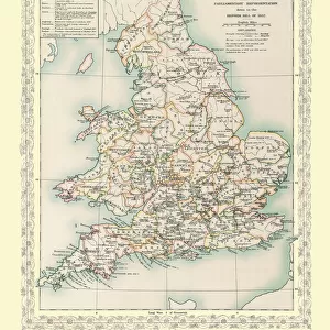
Jigsaw Puzzle : Map of England and Wales as it appeared before the Norman Conquest


![]()
Jigsaw Puzzles from MapSeeker
Map of England and Wales as it appeared before the Norman Conquest
BHISM002
Welcome to the Mapseeker Image library and enter an historic gateway to one of the largest on-line collections of Historic Maps, Nostalgic Views, Vista's and Panorama's from a World gone by.
Media ID 20348252
Jigsaw Puzzle (500 Pieces)
Discover the history of England and Wales with our intriguing jigsaw puzzle from Media Storehouse - BHISM002. This captivating puzzle features an authentic MapSeeker reproduction of a Map of England and Wales as it appeared before the Norman Conquest. Immerse yourself in the rich history and intricate details of this fascinating time period as you piece together the 1000+ puzzle pieces. A perfect activity for history enthusiasts, families, or anyone seeking a challenging and engaging brain teaser. Let the journey to the past begin!
500 piece puzzles are custom made in the UK and hand-finished on 100% recycled 1.5 mm millboard. There is a level of repetition in jigsaw shapes with each matching piece away from its pair. The completed puzzle measures 38x50cm and is delivered packaged in an attractive presentation box specially designed to fit most letter box slots
Jigsaw Puzzles are an ideal gift for any occasion
Estimated Product Size is 38cm x 50.2cm (15" x 19.8")
These are individually made so all sizes are approximate
Artwork printed orientated as per the preview above, with landscape (horizontal) or portrait (vertical) orientation to match the source image.
FEATURES IN THESE COLLECTIONS
> Europe
> United Kingdom
> England
> Maps
> Europe
> United Kingdom
> Wales
> Maps
> Europe
> United Kingdom
> Wales
> Posters
> Europe
> United Kingdom
> Wales
> Related Images
> Maps and Charts
> Related Images
> Maps and Charts
> Wales
> MapSeeker
> Maps from the British Isles
> England with Wales PORTFOLIO
EDITORS COMMENTS
This print showcases the ancient "Map of England and Wales as it appeared before the Norman Conquest (BHISM002)" from MapSeeker. Steeped in history, this remarkable artifact takes us back to a time when kingdoms were born and boundaries were defined. The intricate details etched on this map offer a glimpse into the pre-Norman era, where an amalgamation of Anglo-Saxon tribes and Celtic realms shaped the landscape. From the rolling hills of Wessex to the rugged peaks of Snowdonia, every contour is meticulously depicted, inviting us to explore these lands through our imagination. As we study this visual treasure trove, we can trace rivers meandering across counties and decipher long-forgotten place names that once echoed with stories untold. The absence of modern cities allows us to appreciate how different life must have been during those formative years. This print transports us beyond mere geography; it evokes a sense of wonder about our ancestors' lives and their connection to these lands. It serves as a reminder that beneath layers of conquests and changes over centuries, there lies an enduring spirit rooted in tradition and resilience. Whether displayed in a classroom or adorning your living space, this print sparks curiosity within all who gaze upon it. It invites contemplation about our shared heritage while celebrating the diversity that has shaped England and Wales throughout history. Let this extraordinary piece be both a window into the past and an inspiration for future explorations into our rich cultural tapestry.
MADE IN THE UK
Safe Shipping with 30 Day Money Back Guarantee
FREE PERSONALISATION*
We are proud to offer a range of customisation features including Personalised Captions, Color Filters and Picture Zoom Tools
SECURE PAYMENTS
We happily accept a wide range of payment options so you can pay for the things you need in the way that is most convenient for you
* Options may vary by product and licensing agreement. Zoomed Pictures can be adjusted in the Basket.