Jigsaw Puzzle > Arts > Artists > T > John Tallis
Jigsaw Puzzle : Western Africa 1851


![]()
Jigsaw Puzzles from MapSeeker
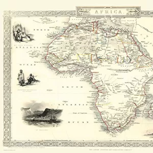
Western Africa 1851
A fine facimile artworked from an antique original map of Western Africa, issued as part of the 1851 edition of John Tallis and Companys " The Illustrated Atlas and Modern History of the World"
Welcome to the Mapseeker Image library and enter an historic gateway to one of the largest on-line collections of Historic Maps, Nostalgic Views, Vista's and Panorama's from a World gone by.
Media ID 20347517
© Mapseeker Publishing Ltd
John Tallis John Tallis Map Tallis Tallis Map West Africa Western Africa
Jigsaw Puzzle (400 Pieces)
Discover the rich history of Western Africa with our exquisite jigsaw puzzle from Media Storehouse. This captivating puzzle features the detailed and intriguing "Western Africa 1851" map by John Tallis and John Rapkin from MapSeeker. A fine facsimile of an original antique map from the 1851 edition of John Tallis and Company's "The Illustrated Atlas," this puzzle brings the past to life with its vibrant colors and intricate lines. Immerse yourself in the exploration and discovery of Western Africa's history, culture, and geography as you piece together this beautiful and educational puzzle.
400 piece puzzles are custom made in the UK and hand-finished on 100% recycled 1.5 mm millboard. There is a level of repetition in jigsaw shapes with each matching piece away from its pair. The completed puzzle measures 31x47cm and is delivered packaged in an attractive presentation box specially designed to fit most letter box slots
Jigsaw Puzzles are an ideal gift for any occasion
Estimated Product Size is 47.2cm x 31.5cm (18.6" x 12.4")
These are individually made so all sizes are approximate
Artwork printed orientated as per the preview above, with landscape (horizontal) or portrait (vertical) orientation to match the source image.
FEATURES IN THESE COLLECTIONS
> Arts
> Artists
> T
> John Tallis
> Maps and Charts
> Related Images
> Maps and Charts
> World
> MapSeeker
> Maps of Africa and Oceana
> Old Maps Showing the Continent of
Western Africa 1851 - A Glimpse into the Rich History of a Vibrant Continent
EDITORS COMMENTS
. This print showcases a fine facsimile artworked from an antique original map of Western Africa, dating back to 1851. Part of John Tallis and Company's renowned "The Illustrated Atlas and Modern History of the World" this exquisite piece offers us a window into the past. As we delve into this old map, we are transported to an era when exploration was at its peak and the world was still being discovered. The intricate details meticulously captured by John Tallis and his collaborator, John Rapkin, bring forth a sense of wonderment about Western Africa's diverse landscapes, cultures, and historical significance. From the vast Sahara Desert in the north to lush rainforests in the south, this map reveals Western Africa's geographical wonders. It highlights major rivers like Niger and Senegal that have shaped civilizations for centuries. Ancient trade routes crisscrossing through bustling cities such as Timbuktu evoke images of vibrant marketplaces filled with exotic goods. Beyond geography, this artwork also serves as a testament to African resilience and cultural heritage. It reminds us that long before colonization or modern borders were established, West Africa thrived with empires like Ghana, Mali, Songhai – centers of artistry and learning that left an indelible mark on history. With each glance at this remarkable print from MapSeeker's collection, we are reminded not only of our shared human
MADE IN THE UK
Safe Shipping with 30 Day Money Back Guarantee
FREE PERSONALISATION*
We are proud to offer a range of customisation features including Personalised Captions, Color Filters and Picture Zoom Tools
SECURE PAYMENTS
We happily accept a wide range of payment options so you can pay for the things you need in the way that is most convenient for you
* Options may vary by product and licensing agreement. Zoomed Pictures can be adjusted in the Basket.