Jigsaw Puzzle > Arts > Artists > T > John Tallis
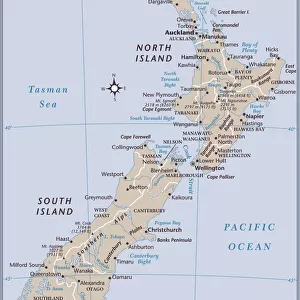
Jigsaw Puzzle : New Zealand 1851


![]()
Jigsaw Puzzles from MapSeeker
New Zealand 1851
A fine facimile artworked from an antique original map of New Zealand, issued as part of the 1851 edition of John Tallis and Companys " The Illustrated Atlas and Modern History of the World"
Welcome to the Mapseeker Image library and enter an historic gateway to one of the largest on-line collections of Historic Maps, Nostalgic Views, Vista's and Panorama's from a World gone by.
Media ID 20347525
© Mapseeker Publishing Ltd
John Tallis John Tallis Map Tallis Map
Jigsaw Puzzle (400 Pieces)
Discover the rich history of New Zealand with our exquisite jigsaw puzzle from Media Storehouse. This intricately detailed puzzle features the captivating "New Zealand 1851" map by John Tallis and John Rapkin from MapSeeker. A fine facsimile artfully reproduced from an antique original map, this puzzle offers a glimpse into the past. Immerse yourself in the intricacies of this 1851 edition of The Illustrated Atlas and bring the history of New Zealand into your home. Perfect for puzzle enthusiasts, history buffs, or anyone seeking a challenging and rewarding pastime. Enjoy the satisfaction of piecing together this beautiful and educational puzzle.
400 piece puzzles are custom made in the UK and hand-finished on 100% recycled 1.5 mm millboard. There is a level of repetition in jigsaw shapes with each matching piece away from its pair. The completed puzzle measures 31x47cm and is delivered packaged in an attractive presentation box specially designed to fit most letter box slots
Jigsaw Puzzles are an ideal gift for any occasion
Estimated Product Size is 31.5cm x 47.2cm (12.4" x 18.6")
These are individually made so all sizes are approximate
Artwork printed orientated as per the preview above, with landscape (horizontal) or portrait (vertical) orientation to match the source image.
FEATURES IN THESE COLLECTIONS
> Arts
> Artists
> T
> John Tallis
> Maps and Charts
> Related Images
> Maps and Charts
> World
> Oceania
> New Zealand
> Maps
> Oceania
> New Zealand
> Related Images
> MapSeeker
> Maps of Africa and Oceana
> Old Maps of New Zealand, Tasmania And
EDITORS COMMENTS
This exquisite print showcases a remarkable piece of history - a fine facsimile artworked from an antique original map of New Zealand dating back to 1851. This map was originally issued as part of the prestigious 1851 edition of John Tallis and Company's "The Illustrated Atlas and Modern History of the World". With intricate details and stunning craftsmanship, this old map offers a glimpse into the past, allowing us to explore the early geography and boundaries of New Zealand. The carefully drawn coastlines, rivers, mountains, and settlements provide a fascinating insight into how this beautiful country appeared over 150 years ago. Created by renowned cartographers John Tallis and John Rapkin, this historic New Zealand map is not only aesthetically pleasing but also serves as an important historical document. It captures the spirit of exploration that characterized the era when maps were meticulously crafted by hand. Whether you are an avid collector or simply appreciate artistry combined with historical significance, this print is sure to captivate your imagination. Display it proudly in your home or office to spark conversations about New Zealand's rich heritage and its place in global history
MADE IN THE UK
Safe Shipping with 30 Day Money Back Guarantee
FREE PERSONALISATION*
We are proud to offer a range of customisation features including Personalised Captions, Color Filters and Picture Zoom Tools
SECURE PAYMENTS
We happily accept a wide range of payment options so you can pay for the things you need in the way that is most convenient for you
* Options may vary by product and licensing agreement. Zoomed Pictures can be adjusted in the Basket.