Jigsaw Puzzle > Maps and Charts > Related Images
Jigsaw Puzzle : Old Map of The Manor of Erdington in Warwickshire 1760


![]()
Jigsaw Puzzles from MapSeeker
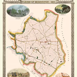
Old Map of The Manor of Erdington in Warwickshire 1760
PL064
Welcome to the Mapseeker Image library and enter an historic gateway to one of the largest on-line collections of Historic Maps, Nostalgic Views, Vista's and Panorama's from a World gone by.
Media ID 20347333
Historic Map Old Town Plan Town Plan Erdington
Jigsaw Puzzle (500 Pieces)
Discover the rich history of Warwickshire with our Old Map of The Manor of Erdington in PL064 from Media Storehouse. This intricately detailed jigsaw puzzle, featuring an authentic map from MapSeeker, transports you back in time to 1760. With countless hours of enjoyment, this puzzle is perfect for puzzle enthusiasts and history buffs alike. Get ready to embark on a captivating journey as you piece together the past.
500 piece puzzles are custom made in the UK and hand-finished on 100% recycled 1.5 mm millboard. There is a level of repetition in jigsaw shapes with each matching piece away from its pair. The completed puzzle measures 38x50cm and is delivered packaged in an attractive presentation box specially designed to fit most letter box slots
Jigsaw Puzzles are an ideal gift for any occasion
Estimated Product Size is 38cm x 50.2cm (15" x 19.8")
These are individually made so all sizes are approximate
Artwork printed orientated as per the preview above, with landscape (horizontal) or portrait (vertical) orientation to match the source image.
FEATURES IN THESE COLLECTIONS
> Europe
> United Kingdom
> England
> Warwickshire
> Related Images
> Maps and Charts
> Related Images
> MapSeeker
> British Town And City Plans
> English & Welsh PORTFOLIO
EDITORS COMMENTS
This print showcases the "Old Map of The Manor of Erdington in Warwickshire 1760 (PL064)". With its intricate details and historical significance, this map offers a fascinating glimpse into the past. The image transports us back to the year 1760, where we can explore the charming village of Erdington as it once was. This meticulously crafted town plan provides a comprehensive overview of the area, capturing every street, building, and landmark with remarkable precision. As we examine this historic map, we are reminded of Erdington's rich heritage and its importance within Warwickshire. The village itself exudes an old-world charm that is beautifully depicted through this vintage cartographic gem. Every line on this map tells a story - from the winding roads that connect different parts of Erdington to the clusters of houses nestled amidst lush greenery. It allows us to imagine what life was like for residents during that era; their daily routines and interactions within this tight-knit community. Whether you have personal ties to Erdington or simply appreciate historical maps, this print serves as a window into another time. Its aesthetic appeal combined with its educational value makes it an ideal addition to any history enthusiast's collection
MADE IN THE UK
Safe Shipping with 30 Day Money Back Guarantee
FREE PERSONALISATION*
We are proud to offer a range of customisation features including Personalised Captions, Color Filters and Picture Zoom Tools
SECURE PAYMENTS
We happily accept a wide range of payment options so you can pay for the things you need in the way that is most convenient for you
* Options may vary by product and licensing agreement. Zoomed Pictures can be adjusted in the Basket.