Jigsaw Puzzle > Arts > Artists > S > Petrus Schenk
Jigsaw Puzzle : Map Regni Hungariae Graeciae Moreae totius Danubii


![]()
Jigsaw Puzzles from Liszt Collection
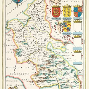
Map Regni Hungariae Graeciae Moreae totius Danubii
Map, Regni Hungariae, Graeciae, Moreae, totius Danubii, adiacentiumque regnorum nec non totius Graeciae et archipelagi, delineatio nova, Petrus Schenk (1660-1718/9), Copperplate print
Liszt Collection of nineteenth-century engravings and images to browse and enjoy
Media ID 19586792
© Artokoloro
1660 1718 9 Copperplate Print Petrus Schenk
Jigsaw Puzzle (500 Pieces)
Discover the intriguing history of Europe with our exquisite jigsaw puzzles from Media Storehouse. Our latest addition to the collection features the detailed and captivating "Map Regni Hungariae Graeciae Moreae totius Danubii" from the Liszt Collection. This stunning antique map, created by Peter Schenk in 1660, showcases the territories of Hungary, Greece, Morea, and the adjacent realms, as well as the entirety of Greece and the archipelago. The intricately designed copperplate print comes to life in our premium puzzle pieces, providing an immersive and educational puzzle-solving experience. Journey back in time and explore the rich history of Europe, one puzzle at a time.
500 piece puzzles are custom made in the UK and hand-finished on 100% recycled 1.5 mm millboard. There is a level of repetition in jigsaw shapes with each matching piece away from its pair. The completed puzzle measures 38x50cm and is delivered packaged in an attractive presentation box specially designed to fit most letter box slots
Jigsaw Puzzles are an ideal gift for any occasion
Estimated Product Size is 50.2cm x 38cm (19.8" x 15")
These are individually made so all sizes are approximate
Artwork printed orientated as per the preview above, with landscape (horizontal) or portrait (vertical) orientation to match the source image.
FEATURES IN THESE COLLECTIONS
> Arts
> Artists
> S
> Petrus Schenk
> Maps and Charts
> Related Images
EDITORS COMMENTS
This print showcases a remarkable piece of cartographic art titled "Map, Regni Hungariae, Graeciae, Moreae, totius Danubii". Created by the talented Petrus Schenk in the late 17th century, this copperplate print is an exquisite representation of Hungary, Greece, and the surrounding regions. With meticulous attention to detail and precision, Schenk's delineation offers a fresh perspective on these lands. The map not only encompasses the entirety of Danube but also includes adjacent kingdoms as well as the entire Greek region and archipelago. It serves as a testament to Schenk's skillful craftsmanship and dedication to capturing geographical accuracy. The rich hues and intricate lines featured in this print bring forth an air of historical significance. As we gaze upon it today, we are transported back in time to an era where exploration was at its peak. This masterpiece allows us to marvel at how our understanding of geography has evolved over centuries. The Liszt Collection proudly presents this extraordinary print for all history enthusiasts and art connoisseurs alike. It serves as a reminder that maps are not merely tools for navigation but also works of art that encapsulate cultural heritage and human curiosity about our world
MADE IN THE UK
Safe Shipping with 30 Day Money Back Guarantee
FREE PERSONALISATION*
We are proud to offer a range of customisation features including Personalised Captions, Color Filters and Picture Zoom Tools
SECURE PAYMENTS
We happily accept a wide range of payment options so you can pay for the things you need in the way that is most convenient for you
* Options may vary by product and licensing agreement. Zoomed Pictures can be adjusted in the Basket.