Jigsaw Puzzle > Maps and Charts > Cyprus
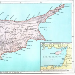
Jigsaw Puzzle : Map of Cyprus, published in 1880


![]()
Jigsaw Puzzles from Fine Art Storehouse
Map of Cyprus, published in 1880
Ancient map of Cyprus. Lithograph, published in 1880
Unleash your creativity and transform your space into a visual masterpiece!
Media ID 13666835
© ZU_09
Coastal Feature Contour Drawing Cyprus European Culture Island Mediterranean Culture Mediterranean Sea Topographic Map Topography Mediterran Obsolete
Jigsaw Puzzle (400 Pieces)
Discover the rich history of Cyprus with our exquisite Jigsaw Puzzle from Media Storehouse's Fine Art Storehouse collection. This captivating puzzle showcases an ancient map of Cyprus, published in 1880, offering a fascinating glimpse into the past. The intricate lithograph design transports you back in time, allowing you to explore the historical geography of this beautiful island nation. Immerse yourself in the puzzle-solving experience, connect the pieces, and uncover the stories hidden within this fine work of art. Bring history to life in your own home with this captivating addition to your collection.
400 piece puzzles are custom made in the UK and hand-finished on 100% recycled 1.5 mm millboard. There is a level of repetition in jigsaw shapes with each matching piece away from its pair. The completed puzzle measures 31x47cm and is delivered packaged in an attractive presentation box specially designed to fit most letter box slots
Jigsaw Puzzles are an ideal gift for any occasion
Estimated Product Size is 47.2cm x 31.5cm (18.6" x 12.4")
These are individually made so all sizes are approximate
Artwork printed orientated as per the preview above, with landscape (horizontal) or portrait (vertical) orientation to match the source image.
FEATURES IN THESE COLLECTIONS
> Fine Art Storehouse
> Map
> Historical Maps
> Fine Art Storehouse
> Top Sellers - Art Prints
> Asia
> Cyprus
> Related Images
> Europe
> Related Images
> Maps and Charts
> Early Maps
> Maps and Charts
> Related Images
EDITORS COMMENTS
This lithograph, titled "Map of Cyprus, published in 1880" takes us on a journey through time to explore the ancient topography and rich history of this Mediterranean island. The intricate details engraved onto the print showcase the artistry and precision of cartography during that era. The map depicts Cyprus, an island located in the eastern part of the Mediterranean Sea. Its horizontal layout beautifully captures the coastal features and contours of this historic landmass. The lithograph highlights not only its geographical aspects but also provides insight into European culture from over a century ago. As we delve into this obsolete piece of artwork, we are transported back to a time when maps were meticulously crafted by hand. This particular print showcases how topographic maps were created before modern technology took over. The coastline is intricately drawn, showcasing both natural formations and man-made structures along its shores. It serves as a testament to Cyprus' historical significance as an important trading hub within the Mediterranean region. With no people present in this image, it allows us to focus solely on appreciating the beauty and complexity of this ancient map. As we gaze upon it today, we can't help but marvel at how much has changed since its creation in 1880 while also recognizing that some elements have remained timeless throughout history. This photograph taken in 2015 preserves not just an artifact from our past but also reminds us of our connection to European culture and heritage through cartography's lens.
MADE IN THE UK
Safe Shipping with 30 Day Money Back Guarantee
FREE PERSONALISATION*
We are proud to offer a range of customisation features including Personalised Captions, Color Filters and Picture Zoom Tools
SECURE PAYMENTS
We happily accept a wide range of payment options so you can pay for the things you need in the way that is most convenient for you
* Options may vary by product and licensing agreement. Zoomed Pictures can be adjusted in the Basket.