Jigsaw Puzzle > Arts > Photorealistic artworks > Detailed art pieces > Masterful detailing in art
Jigsaw Puzzle : Asia Map - illustration


![]()
Jigsaw Puzzles from Fine Art Storehouse
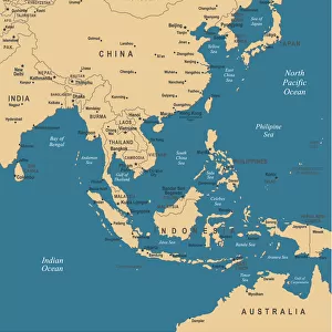
Asia Map - illustration
Colored Map of Asia with Country Names and Capital Cities The url of the reference to map is: http:/lib.utexas.edu/maps/world_maps/time_zones_ref_2011.pdf. In addition - some city locations were taken from: http:/lib.utexas.edu/maps/world_maps/txu-oclc-264266980-world_pol_2008-2.jpg. The illustration completed August 14, 2015 and created in Corel Draw 1 layer of data used for the detailed outline of the land
Unleash your creativity and transform your space into a visual masterpiece!
Media ID 14777521
Jigsaw Puzzle (500 Pieces)
Explore the vibrant and diverse continent of Asia with our intricately designed jigsaw puzzles from Media Storehouse. Our Asia Map puzzle, inspired by a fine art illustration, features an exquisitely colored representation of Asia, complete with country names and capital cities. Challenge yourself or your family to piece together this beautiful puzzle, perfect for educational and entertaining activities. Immerse yourself in the rich cultural tapestry of Asia and expand your geographical knowledge with every completed puzzle piece. Get ready to embark on an enlightening journey with Media Storehouse's Asia Map puzzle.
500 piece puzzles are custom made in the UK and hand-finished on 100% recycled 1.5 mm millboard. There is a level of repetition in jigsaw shapes with each matching piece away from its pair. The completed puzzle measures 38x50cm and is delivered packaged in an attractive presentation box specially designed to fit most letter box slots
Jigsaw Puzzles are an ideal gift for any occasion
Estimated Product Size is 50.2cm x 38cm (19.8" x 15")
These are individually made so all sizes are approximate
Artwork printed orientated as per the preview above, with landscape (horizontal) or portrait (vertical) orientation to match the source image.
FEATURES IN THESE COLLECTIONS
> Fine Art Storehouse
> Map
> Map Illustrations
> Arts
> Photorealistic artworks
> Detailed art pieces
> Masterful detailing in art
> Asia
> Related Images
> Europe
> France
> Canton
> Landes
> Maps and Charts
> Related Images
EDITORS COMMENTS
This print showcases a beautifully colored map of Asia, complete with country names and capital cities. The intricate details of this illustration were meticulously crafted using Corel Draw software, ensuring accuracy and precision. Created on August 14,2015, this artwork represents a labor of love that celebrates the diverse geography and cultural richness of the Asian continent. The reference for this map can be found at http:/lib. utexas. edu/maps/world_maps/time_zones_ref_2011. pdf, while additional city locations were sourced from http:/lib. utexas. edu/maps/world_maps/txu-oclc-264266980-world_pol_2008-2. jpg. These reliable sources contribute to the authenticity and reliability of the information depicted in this stunning piece. As you explore this print, allow yourself to immerse in the vastness of Asia's landscapes - from snow-capped mountains to lush rainforests; bustling metropolises to serene rural areas. Each country is clearly labeled alongside its respective capital city, providing an educational experience as well. Whether you are an avid traveler or simply fascinated by world cultures, this print serves as both an aesthetic delight and a valuable resource. Hang it proudly on your wall or gift it to someone who shares your passion for exploration. Let this vibrant depiction ignite your curiosity about Asia's wonders and inspire dreams of future adventures across its diverse nations.
MADE IN THE UK
Safe Shipping with 30 Day Money Back Guarantee
FREE PERSONALISATION*
We are proud to offer a range of customisation features including Personalised Captions, Color Filters and Picture Zoom Tools
SECURE PAYMENTS
We happily accept a wide range of payment options so you can pay for the things you need in the way that is most convenient for you
* Options may vary by product and licensing agreement. Zoomed Pictures can be adjusted in the Basket.