Jigsaw Puzzle > North America > United States of America > Indiana > Indianapolis
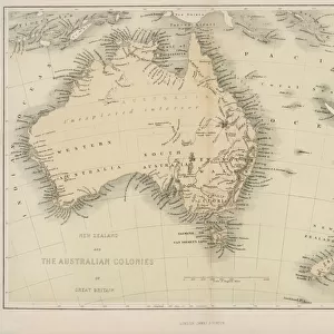
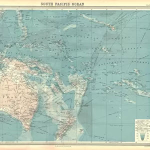
Jigsaw Puzzle : Oceania map 1889


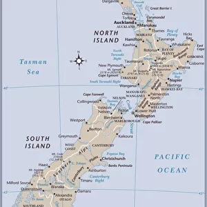
![]()
Jigsaw Puzzles from Fine Art Storehouse
Oceania map 1889
Indiana Educational Series The Complete Geography - Indianapolis 1889
Unleash your creativity and transform your space into a visual masterpiece!
THEPALMER
Media ID 14756344
© This content is subject to copyright
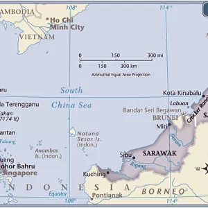
Australasia Australia Indonesia Malaysia New Zealand Oceania Pacific Papua Solomon Tasmania
Jigsaw Puzzle (500 Pieces)
Discover the wonders of geography with the Media Storehouse range of jigsaw puzzles, featuring the intricately detailed and historically significant "Oceania Map 1889" by THEPALMER from the Fine Art Storehouse. This captivating puzzle, part of the Indiana Educational Series The Complete Geography published in Indianapolis in 1889, invites you on a journey to explore the vast expanse of Oceania in a unique and engaging way. Immerse yourself in the rich history and intricate details of this beautiful map as you piece together the various islands and landmasses, making it a perfect activity for families, educators, or anyone seeking a challenging and rewarding puzzle experience. With each completed puzzle, expand your knowledge of the world and add a touch of history to your home.
500 piece puzzles are custom made in the UK and hand-finished on 100% recycled 1.5 mm millboard. There is a level of repetition in jigsaw shapes with each matching piece away from its pair. The completed puzzle measures 38x50cm and is delivered packaged in an attractive presentation box specially designed to fit most letter box slots
Jigsaw Puzzles are an ideal gift for any occasion
Estimated Product Size is 50.2cm x 38cm (19.8" x 15")
These are individually made so all sizes are approximate
Artwork printed orientated as per the preview above, with landscape (horizontal) or portrait (vertical) orientation to match the source image.
FEATURES IN THESE COLLECTIONS
> Fine Art Storehouse
> Map
> Historical Maps
> Asia
> Indonesia
> Related Images
> Asia
> Malaysia
> Related Images
> Maps and Charts
> Related Images
> North America
> United States of America
> Indiana
> Indianapolis
> Oceania
> Australia
> Related Images
> Oceania
> New Zealand
> Maps
EDITORS COMMENTS
This print showcases an exquisite piece of history, the Oceania map from 1889. Part of the Indiana Educational Series The Complete Geography, this particular edition hails from Indianapolis in the late 19th century. A true testament to human curiosity and exploration, this vintage map offers a glimpse into how our understanding of the world has evolved over time. The intricate details on this print highlight various regions within Oceania, including Malaysia, Tasmania, Australasia, Australia, Indonesia, New Zealand, Papua New Guinea and many more. Each country is meticulously labeled with its name and boundaries as they were known back then. This visual representation not only serves as a geographical reference but also tells stories of colonization and cultural diversity that have shaped these lands. With its warm color palette and aged appearance, this print transports us to a bygone era when cartography was both artistry and science. It invites us to appreciate the craftsmanship involved in creating such maps before digital technology took over. Whether you are an avid collector or simply fascinated by historical artifacts like this one, "Oceania Map 1889" by THEPALMER is sure to add character to any space it adorns. Let your imagination wander through time as you explore the intricacies of this remarkable piece – a tangible link between past explorations and present-day knowledge.
MADE IN THE UK
Safe Shipping with 30 Day Money Back Guarantee
FREE PERSONALISATION*
We are proud to offer a range of customisation features including Personalised Captions, Color Filters and Picture Zoom Tools
SECURE PAYMENTS
We happily accept a wide range of payment options so you can pay for the things you need in the way that is most convenient for you
* Options may vary by product and licensing agreement. Zoomed Pictures can be adjusted in the Basket.