Jigsaw Puzzle > Animals > Mammals > Muridae > Water Mouse
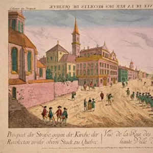
Jigsaw Puzzle : Map of Canada and Greenland (etching, 1730)
")
")


![]()
Jigsaw Puzzles from Fine Art Finder
Map of Canada and Greenland (etching, 1730)
LRI4706965 Map of Canada and Greenland (etching, 1730) by Delisle, Guillaume (1675-1726); Private Collection; (add.info.: Map of Canada and Greenland - Strong Water Extracted from the " New Atlas Containing All Parts of the World" 1730 by Guillaume de L Isle (1675-1726)); Luisa Ricciarini; French, out of copyright
Media ID 22278670
© Luisa Ricciarini / Bridgeman Images
Atlas Book Danish Danish Women Denmark Greenland Nordic Countries America Continent Canadians Geographical Map
Jigsaw Puzzle (500 Pieces)
Discover the rich history of cartography with our exquisite jigsaw puzzle from Media Storehouse. This intriguing puzzle features a stunning etching of "Map of Canada and Greenland (1730)" by Guillaume Delisle, an influential French cartographer of the early 18th century. Immerse yourself in the intricacies of this fine art masterpiece, replicated from the original etching by Luisa Ricciarini and sourced from Fine Art Finder. Engage in a captivating puzzle experience, bringing history to life piece by piece.
500 piece puzzles are custom made in the UK and hand-finished on 100% recycled 1.5 mm millboard. There is a level of repetition in jigsaw shapes with each matching piece away from its pair. The completed puzzle measures 38x50cm and is delivered packaged in an attractive presentation box specially designed to fit most letter box slots
Jigsaw Puzzles are an ideal gift for any occasion
Estimated Product Size is 50.2cm x 38cm (19.8" x 15")
These are individually made so all sizes are approximate
Artwork printed orientated as per the preview above, with landscape (horizontal) or portrait (vertical) orientation to match the source image.
FEATURES IN THESE COLLECTIONS
> Fine Art Finder
> Artists
> Guillaume Delisle
> Animals
> Mammals
> Muridae
> Water Mouse
> Animals
> Mammals
> Muridae
> Western Mouse
> Europe
> Denmark
> Related Images
> Europe
> United Kingdom
> Scotland
> Western Isles
> Related Images
EDITORS COMMENTS
This print showcases an exquisite etching from 1730, depicting a Map of Canada and Greenland. Created by the talented Guillaume Delisle, this historical piece is now part of a private collection. The map was extracted from the renowned "New Atlas Containing All Parts of the World" published in 1730. With intricate details and precision, Delisle's work beautifully captures the geographical features of Canada and Greenland. This map serves as a valuable resource for understanding the landscape and boundaries during that time period. The artist's expertise shines through in every line and contour, showcasing his mastery in cartography. As we gaze upon this artwork, we are transported back to the 18th century when explorers were venturing into uncharted territories. The inclusion of Denmark on this map reminds us of Greenland's connection to its European colonizers. It also highlights the significance of Danish influence in North America during that era. Luisa Ricciarini has skillfully captured this historic etching through her lens, preserving it for future generations to appreciate. Through her photography, she allows us to delve into history and explore not only the physical geography but also gain insight into cultural connections between nations. This print is a testament to both artistic brilliance and historical importance – a true treasure for any art enthusiast or history buff alike.
MADE IN THE UK
Safe Shipping with 30 Day Money Back Guarantee
FREE PERSONALISATION*
We are proud to offer a range of customisation features including Personalised Captions, Color Filters and Picture Zoom Tools
SECURE PAYMENTS
We happily accept a wide range of payment options so you can pay for the things you need in the way that is most convenient for you
* Options may vary by product and licensing agreement. Zoomed Pictures can be adjusted in the Basket.