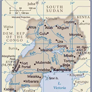
Home > Africa > Uganda > Lakes > Lake Victoria
'Ouganda: Le Nord-Est Africain, 1914. Creator: Unknown

![]()
Wall Art and Photo Gifts from Heritage Images
'Ouganda: Le Nord-Est Africain, 1914. Creator: Unknown
'Ouganda: Le Nord-Est Africain, 1914. From "Grande Geographie Bong Illustree", 1914
Heritage Images features heritage image collections
Media ID 36296189
© The Print Collector/Heritage Images
Colonies Colony East Africa East African Lake Victoria Nile River Nile Source The Nile Uganda Ugandan Victoria Nyanza Volcano
FEATURES IN THESE COLLECTIONS
> Africa
> Uganda
> Lakes
> Lake Victoria
> Africa
> Uganda
> Lakes
> Related Images
> Africa
> Uganda
> Related Images
> Maps and Charts
> British Empire Maps
Ouganda - Le Nord-Est Africain,
EDITORS COMMENTS
a captivating black and white print from the 1910s, showcases the eastern region of Africa, specifically Uganda. The image is taken from the renowned French geographical publication, "Grande Geographie Bong Illustree," published in 1914. The print displays an intricate and detailed map of the area, highlighting various geographical features such as the source of the Nile, Lake Victoria, and Mount Elgon. The Nile, the longest river in the world, is depicted winding its way through the landscape, providing life to the surrounding regions. Mount Elgon, an active volcano straddling the border between Uganda and Kenya, is prominently featured in the print. Its symmetrical shape and snow-capped peak make it a striking addition to the landscape. Lake Victoria, Africa's largest lake by area, is also depicted, with its shores extending into present-day Uganda, Kenya, and Tanzania. The British Empire's colonization of Uganda during the late 19th and early 20th centuries is evident in the print, with the country's borders clearly defined. The print serves as a testament to the European exploration and mapping of Africa during this period. The print's intricate engraving and attention to detail make it a valuable historical artifact, providing insight into the geography and colonization of eastern Africa during the early 20th century. Despite the unknown creator, the print remains a significant piece of historical documentation, showcasing the beauty and complexity of the African continent. The print's age and historical significance make it a valuable addition to any collection, whether for educational or decorative purposes. Its intricate details and historical importance make it a fascinating glimpse into the past, providing a window into the exploration and colonization of Africa during the 20th century.
MADE IN THE UK
Safe Shipping with 30 Day Money Back Guarantee
FREE PERSONALISATION*
We are proud to offer a range of customisation features including Personalised Captions, Color Filters and Picture Zoom Tools
SECURE PAYMENTS
We happily accept a wide range of payment options so you can pay for the things you need in the way that is most convenient for you
* Options may vary by product and licensing agreement. Zoomed Pictures can be adjusted in the Basket.